
Keywords
Computer Science and Digital Science
- A6.1.1. Continuous Modeling (PDE, ODE)
- A6.1.2. Stochastic Modeling
- A6.1.4. Multiscale modeling
- A6.1.5. Multiphysics modeling
- A6.2.1. Numerical analysis of PDE and ODE
- A6.2.2. Numerical probability
- A6.2.3. Probabilistic methods
- A6.3.3. Data processing
- A6.3.4. Model reduction
- A6.3.5. Uncertainty Quantification
- A6.5.2. Fluid mechanics
- A6.5.3. Transport
- A6.5.4. Waves
Other Research Topics and Application Domains
- B3.1. Sustainable development
- B3.2. Climate and meteorology
- B3.3.2. Water: sea & ocean, lake & river
- B3.3.3. Nearshore
- B3.3.4. Atmosphere
- B3.4.1. Natural risks
- B3.4.3. Pollution
- B4.3.2. Hydro-energy
- B4.3.3. Wind energy
- B8.3. Urbanism and urban planning
- B8.4.1. Crisis management
- B9.11.1. Environmental risks
1 Team members, visitors, external collaborators
Research Scientist
-
Antoine Rousseau [
Team leader , Inria, Researcher, HDR]
Faculty Members
- Carole Delenne [Univ de Montpellier, Associate Professor, HDR]
- Pascal Finaud Guyot [Univ de Montpellier, Associate Professor]
- Vincent Guinot [Univ de Montpellier, Professor, HDR]
- Gwladys Toulemonde [Univ de Montpellier]
PhD Students
- Vita Ayoub [Luxembourg Institute of Science and Technology / Univ Montpellier]
- Yassine Bel Ghaddar [Berger-Levrault , Univ de Montpellier / USMBA (Morocco)]
- Joao Guilherme Caldas Steinstraesser [Inria]
- Cecile Choley [Ecole Nationale du Génie de l'Eau et de l'Environnement de Strasbourg]
- Joseph Luis Kahn Casapia [Univ de Montpellier, until Feb 2020]
- Joseph Luis Kahn Casapia [Inria, from Mar 2020]
Interns and Apprentices
- Violeta Montoya Coronado [Inria, from Mar 2020 until Aug 2020]
Administrative Assistant
- Annie Aliaga [Inria]
2 Overall objectives
Coastal areas are increasingly threatened by global warming-induced sea level rise. At the same time, 60% of the world population lives in a 100 km wide coastal strip (80% within 30 km from the shore in French Brittany). This is why coastlines are concerned with many issues of various types: economical, ecological, social, political, etc. Coastal areas are natural interfaces between various media (e.g. wind/sea/sand/land). The physical processes acting on these media have very different time scales, hence the need to build complex systems coupling nonlinear partial differential equations and random processes to describe them. To address these crucial issues, LEMON is an interdisciplinary team working on the design, analysis and application of deterministic and stochastic models for inland and marine littoral processes, with an emphasis on both standalone models and hybrid systems.
The spot of Montpellier offers large opportunities:
- additionally to IMAG 1 and HSM2, we interact with several local academic research partners. To mention but a few examples, we collaborate with UMR MISTEA (pollution and remediation of water resources) and UMR LISAH (hydrology in agricultural areas). Regular contacts are also maintained with UMR Geosciences (morphodynamics), UMR G-Eau (hydraulics, data assimilation and flood economy), UMR MARBEC (lagoon environment).
- The LEMON members are involved in projects funded by the current NUMEV Labex and actively participate in new initiatives pertaining to sea and coast modelling, both through the recently awarded MUSE project in Montpellier and through external (national, European, international) calls.
- From the transfer & innovation viewpoint, the team members already interact with several local partners such as Cereg Ingénierie, IRT Saint-Exupéry, Tour du Valat, Predict Services, Artelia, Montpellier Métropole and Berger-Levrault.
- Regional urban development and land use policies are natural application fields for the developments undertaken in LEMON.
The general scope of the LEMON project-team is to develop mathematical and computational methods for the modelling of hydraulic and hydrodynamic processes. The mathematical tools used are deterministic (PDEs, ODEs) and/or probabilistic (extreme value theory). Applications range from regional oceanography to coastal management, including risk assessment for natural hazards on the coastline (submersion and urban floods, tsunamis, pollution).
LEMON is a common research team between IMAG (UM, CNRS), Inria and HSM (UM, CNRS, IRD), whose faculty members have never been associated to Inria groups in the past. All fellows share a strong background in mathematical modelling, together with a taste for applications to the littoral environment. As reflected in the team contributions, the research conducted by LEMON is interdisciplinary 3, thanks to the team members expertise (deterministic and stochastic modelling, computational and experimental aspects) and to regular collaborations with scientists from other domains. We believe this is both an originality and a strength for LEMON.
3 Research program
3.1 Foreword
The team has three main scientific objectives. The first is to develop new models and advanced mathematical methods for inland flow processes. The second is to investigate the derivation and use of coupled models for marine and coastal processes. The third is to develop theoretical methods to be used in the mathematical models serving the first two objectives. As mentioned above, the targeted applications cover PDE models and related extreme events using a hierarchy of models of increasing complexity.
LEMON members also contribute to research projects that are not in the core of the team topics and that correspond to external collaborations: they are mentioned in the fourth section below.
In every section, people involved in the project are listed in alphabetical order, except for the first one (underlined) which corresponds to the leading scientist on the corresponding objective.
3.2 Inland flow processes
3.2.1 Shallow water models with porosity
State of the Art
Simulating urban floods and free surface flows in wetlands requires considerable computational power. Two-dimensional shallow water models are needed. Capturing the relevant hydraulic detail often requires computational cell sizes smaller than one meter. For instance, meshing a complete urban area with a sufficient accuracy would require to cells, and simulating one second often requires several CPU seconds. This makes the use of such model for crisis management impossible. Similar issues arise when modelling wetlands and coastal lagoons, where large areas are often connected by an overwhelming number of narrow channels, obstructed by vegetation and a strongly variable bathymetry. Describing such channels with the level of detail required in a 2D model is impracticable. A new generation of models overcoming this issue has emerged over the last 20 years: porosity-based shallow water models. They are obtained by averaging the two-dimensional shallow water equations over large areas containing both water and a solid phase 45. The size of a computational cell can be increased by a factor 10 to 50 compared to a 2D shallow water model, with CPU times reduced by 2 to 3 orders of magnitude 64. While the research on porosity-based shallow water models has accelerated over the past decade 59, 77, 80, 55, 54, 64, 72, 73, 86, 87, a number of research issues remain pending.
Four year research objectives
The research objectives are (i) to improve the upscaling of the flux and source term models to be embedded in porosity shallow water models, (ii) to validate these models against laboratory and in situ measurements. Improving the upscaled flux and source term models for urban applications requires that description of anisotropy in porosity models be improved to account for the preferential flows induced by building and street alignment. The description of the porosity embedded in the most widespread porosity approach, the so-called Integral Porosity model 77, 57, has been shown to provide an incomplete description of the connectivity properties of the urban medium. Firstly, the governing equations are strongly mesh-dependent because of consistency issues 57. Secondly, the flux and source term models fail to reproduce the alignment with the main street axes in a number of situations 56. Another path for improvement concerns the upscaling of obstacle-induced drag terms in the presence of complex geometries. Recent upscaling research results obtained by the LEMON team in collaboration with Tour du Valat4 suggest that the effects of microtopography on the flow cannot be upscaled using "classical" equation-of-state approaches, as done in most hydraulic models. A totally different approach must be proposed.
During this 4-year period, we will work to develop and validate improved flux and source term closures in the presence of strongly anisotropic urban geometries and in the presence of strongly variable topography. Validation will involve not only the comparison of porosity model outputs with refined flow simulation results, but also the validation against experimental data sets and real scale events. No experimental data set allowing for a sound validation of flux closures in porosity models can be found in the literature. Laboratory experiments will be developed specifically in view of the validation of porosity models. Such experiments will be set up and carried out in collaboration with the Université Catholique de Louvain (UCL), that has an excellent track record in experimental hydraulics and the development of flow monitoring and data acquisition equipment. These activities will take place in the framework of the PoroCity Associate International Laboratory (see next paragraph).
People
Vincent Guinot, Carole Delenne, Pascal Finaud-Guyot, Antoine Rousseau.
External collaborations
- Tour du Valat (O. Boutron): the partnership with TdV focuses on the development and application of depth-dependent porosity models to the simulation of coastal lagoons, where the bathymetry and geometry is too complex to be represented using refined flow models.
- University of California Irvine (B. Sanders): the collaboration with UCI started in 2014 with research on the representation of urban anisotropic features in integral porosity models 64. It has led to the development of the Dual Integral Porosity model 58. Ongoing research focuses on improved representations of urban anisotropy in urban floods modelling.
- Université Catholique de Louvain - UCL (S. Soares-Frazão): UCL is one of the few places with experimental facilities allowing for the systematic, detailed validation of porosity models. The collaboration with UCL started in 2005 and will continue with the PoroCity Associate International Laboratory proposal. In this proposal, a four year research program is set up for the validation, development and parametrization of shallow water models with porosity.
- Luxembourg Institute of Technology (R. Hostache): the collaboration with LIST started in 2018 with the project CASCADE funded by the Fond National de la Recherche du Luxembourg, and the co-direction of Vita Ayoub. The depth-dependant porosity model is applied to simulate the flooding of the Severn river (UK) during past events and validated against various measurements such as remotely sensed flood extents, and water levels at gauging stations.
3.2.2 Forcing
State of the Art
Reproducing optimally realistic spatio-temporal rainfall fields is of salient importance to the forcing of hydrodynamic models. This challenging task requires combining intense, usual and dry weather events. Far from being straightforward, this combination of extreme and non-extreme scenarii requires a realistic modelling of the transitions between normal and extreme periods. 68 have proposed, in a univariate framework, a statistical model that can serve as a generator and that takes into account low, moderate and intense precipitation. In the same vein, 88 developed a bivariate model. However, its extension to a spatial framework remains a challenge. Existing spatial precipitation stochastic generators are generally based on Gaussian spatial processes 29, 66, that are not adapted to generate extreme rainfall events. Recent advances in spatio-temporal extremes modelling based on generalized Pareto processes 48, 83 and semi-parametric simulation techniques 36 are very promising and could form the base for relevant developments in our framework.
Four year research objectives
The purpose is to develop stochastic methods for the simulation of realistic spatio-temporal processes integrating extreme events. Two steps are identified. The first one is about the simulation of extreme events and the second one concerns the combination of extreme and non extreme events in order to build complete, realistic precipitations time series. As far as the first step is concerned, a first task is to understand and to model the space-time structure of hydrological extremes such as those observed in the French Mediterranean basin, that is known for its intense rainfall events (Cevenol episodes), which have recently received increased attention. We will propose modelling approaches based on the exceedance, which allows the simulated fields to be interpreted as events. Parametric, semi-parametric and non-parametric approaches are currently under consideration. They would allow a number of scientific locks to be removed. Examples of such locks are e.g. accounting for the temporal dimension and for various dependence structures (asymptotic dependence or asymptotic independence possibly depending on the dimension and/or the distance considered). Methodological aspects are detailed in Section 3.4.1. The second step, which is not straightforward, consists in combining different spatio-temporal simulations in order to help to ultimately develop a stochastic precipitation generator capable of producing full precipitation fields, including dry and non-extreme wet periods.
People
Gwladys Toulemonde, Carole Delenne, Vincent Guinot.
External collaborations
The Cerise (2016-2018) and Fraise (2019-2021) projects (see 10.3), led by Gwladys Toulemonde, are funded by the action MANU (MAthematical and Numerical methods) of the CNRS LEFE program 5. Among others, they aim to propose methods for simulating scenarii integrating spatio-temporal extremes fields with a possible asymptotic independence for impact studies in environmental sciences. Among the members of this project, Jean-Noel Bacro (IMAG, UM), Carlo Gaetan (DAIS, Italy) and Thomas Opitz (BioSP, MIA, INRAE) are involved in the first step as identified in the research objectives of the present sub-section. Denis Allard (BioSP, MIA, INRAE), Julie Carreau (IRD, HSM) and Philippe Naveau (CNRS, LSCE) will be involved in the second one.
3.2.3 Parametrization of shallow water models with porosity
State of the Art
Numerical modelling requires data acquisition, both for model validation and for parameter assessment. Model benchmarking against laboratory experiments is an essential step and is an integral part of the team's strategy. However, scale model experiments may have several drawbacks: (i) experiments are very expensive and extremely time-consuming, (ii) experiments cannot always be replicated, and measurement have precision and reliability limitations, (iii) dimensional similarity (in terms of geometry and flow characteristic variables such as Froude or Reynolds numbers) cannot always be preserved.
An ideal way to obtain data would be to carry out in situ measurements. But this would be too costly at the scale of studied systems, not to mention the fact that field may become impracticable during flood periods.
Geographical and remote sensing data are becoming widely available with high spatial and temporal resolutions. Several recent studies have shown that flood extents can be extracted from optical or radar images 51, for example: to characterize the flood dynamics of great rivers 69, to monitor temporary ponds 81, but also to calibrate hydrodynamics models and assess roughness parameters (e.g. 90.
Upscaled models developed in LEMON (see 3.2.1) embed new parameters that reflect the statistical properties of the medium geometry and the subgrid topography. New methods are thus to be developed to characterize such properties from remote sensing and geographical data.
Four year research objectives
This research line consists in deriving methods and algorithms for the determination of upscaled model parameters from geodata.
For applications in urban areas, it is intended to extract information on the porosity parameters from National geographical survey databases largely available in developed countries. Such databases usually incorporate separate layers for roads, buildings, parking lots, yards, etc. Most of the information is stored in vector form, which can be expected to make the treatment of urban anisotropic properties easier than with a raster format. In developing countries, data is made increasingly available over the world thanks to crowdsourcing (e.g. OpenStreetMap) the required level of detail sometimes not available in vector format, especially in suburban areas, where lawns, parks and other vegetated areas, that may also contribute to flood propagation and storage, are not always mapped. In this context, the necessary information can be extracted from aerial and/or satellite images, that are widely available and the spatial resolution of which improves constantly, using supervised classification approaches.
For applications in great rivers the main objective is to develop an efficient framework for optimally integrating remote sensing derived flood information to compensate the lack of observation related to riverbed bathymetry and river discharge. The effective integration of such remote sensing-derived flood information into hydraulic models remains a critical issue. In partnership with R. Hostache (LIST), we will investigate new ways for making use of Satellite Earth Observation data (i.e. flooded areas and water level estimates derived from Synthetic Aperture Radar (SAR) data collections) for retrieving uncertain model parameters and boundary conditions. The method will be developed and validated using synthetically generated data sets as well as real-event data retrieved from the European Space Agency’s archives. Extensive testing will be carried out in a number of high magnitude events recorded over the Severn (United Kingdom) and Zambezi (Mozambique) floodplain areas.
In wetlands applications, connectivity between different ponds is highly dependent on the free surface elevation, thus conditioning the presence of a flow. Characterizing such connectivity requires that topographical variations be known with high accuracy. Despite the increased availability of direct topographic measurements from LiDARS on riverine systems, data collection remains costly when wide areas are involved. Data acquisition may also be difficult when poorly accessible areas are dealt with. If the amount of topographic points is limited, information on elevation contour lines can be easily extracted from the flood dynamics visible in simple SAR or optical images. A challenge is thus to use such data in order to estimate continuous topography on the floodplain combining topographic sampling points and located contour lines the levels of which are unknown or uncertain.
People
Carole Delenne, Vincent Guinot, Antoine Rousseau, Pascal Finaud-Guyot
External collaborations
- A first attempt for topography reconstruction in wetlands was done in collaboration with J.-S. Bailly (LISAH) in 2016 46. We will reactivate this research track within the 4-year period.
- Porosity model calibration for application on great rivers will be done in the framework of CASCADE project in collaboration with R. Hostache (LIST).
- A collaboration started with the LISAH laboratory to investigate the feasibility of depth-dependent porosity laws reconstruction over cultivates areas. LISAH personel involved: D. Feurer, D. Raclot.
3.2.4 Inland hydrobiological systems
State of the Art
Water bodies such as lakes or coastal lagoons (possibly connected to the sea) located in high human activity areas are subject to various kinds of stress such as industrial pollution, high water demand or bacterial blooms caused by freshwater over-enrichment. For obvious environmental reasons, these water resources have to be protected, hence the need to better understand and possibly control such fragile ecosystems to eventually develop decision-making tools. From a modelling point of view, they share a common feature in that they all involve interacting biological and hydrological processes. According to 49, models may be classified into two main types: “minimal dynamic models” and “complex dynamic models”. These two model types do not have the same objectives. While the former are more heuristic and rather depict the likelihood of considered processes, the latter are usually derived from fundamental laws of biochemistry or fluid dynamics. Of course, the latter necessitate much more computational resources than the former. In addition, controlling such complex systems (usually governed by PDEs) is by far more difficult that controlling the simpler ODE-driven command systems.
LEMON has already contributed both to the reduction of PDE models for the simulation of water confinement in coastal lagoons 50, 30 and to the improvement of ODE models in order to account for space-heterogeneity of bioremediation processes in water resources 28.
Four year research objectives
In collaboration with colleagues from the ANR-ANSWER project and colleagues from INRAE, our ambition is to improve existing models of lagoon/marine ecosystems by integrating both accurate and numerically affordable coupled hydrobiological systems. A major challenge is to find an optimal trade-off between the level of detail in the description of the ecosystem and the level of complexity in terms of number of parameters (in particular regarding the governing equations for inter-species reactions). The model(s) should be able to reproduce the inter-annual variability of the observed dynamics of the ecosystem in response to meteorological forcing. This will require the adaptation of hydrodynamics equations to such time scales (reduced/upscaled models such as porosity shallow water models (see Section 3.2.1) will have to be considered) together with the coupling with the ecological models. At short time scales (i.e. the weekly time scale), accurate (but possibly CPU-consuming) 3D hydrodynamic models processes (describing thermal stratification, mixing, current velocity, sediment resuspension, wind waves...) are needed. On the longer term, it is intended to develop reduced models accounting for spatial heterogeneity.
Over the 4-year period, the team will focus on two main application projects:
- the ANR ANSWER project (2017-2021, with INRAE Montpellier and LEESU) focusing on the cyanobacteria dynamics in lagoons and lakes. A PhD student is co-advised by Antoine Rousseau in collaboration with Céline Casenave (INRAE, Montpellier).
- the long term collaboration with Alain Rapaport (INRAE Montpellier) will continue both on the bioremediation of water resources such as the Tunquen lagoon in Chile and with a new ongoing project on water reuse (converting wastewater into water that can be reused for other purposes such as irrigation of agricultural fields). Several projects are submitted to the ANR and local funding structures in Montpellier.
People
Céline Casenave (INRAE Montpellier), Antoine Rousseau, Vincent Guinot, Joseph Luis Kahn Casapia.
External collaborations
- ANR ANSWER consortium: Céline Casenave (UMR MISTEA, INRAE Montpellier), Brigitte Vinçon-Leite (UM LEESU, ENPC), Jean-François Humbert (UMR IEES, UPMC). ANSWER is a French-Chinese collaborative project that focuses on the modelling and simulation of eutrophic lake ecosystems to study the impact of anthropogenic environmental changes on the proliferation of cyanobacteria. Worldwide the current environmental situation is preoccupying: man-driven water needs increase, while the quality of the available resources is deteriorating due to pollution of various kinds and to hydric stress. In particular, the eutrophication of lentic ecosystems due to excessive inputs of nutrients (phosphorus and nitrogen) has become a major problem because it promotes cyanobacteria blooms, which disrupt the functioning and the uses of the ecosystems.
- A. Rousseau has a long lasting collaboration with Alain Rapaport (UMR MISTEA, INRAE Montpellier) and Héctor Ramirez (CMM, Université du Chili).
3.3 Marine and coastal systems
3.3.1 Multi-scale ocean modelling
The expertise of LEMON in this scientific domain is more in the introduction and analysis of new boundary conditions for ocean modelling systems, that can be tested on academical home-designed test cases. This is in the core of Antoine Rousseau's contributions over the past years. The real implementation, within operational ocean models, has to be done thanks to external collaborations which have already started with LEMON (see below).
State of the Art
In physical oceanography, all operational models - regardless of the scale they apply to - are derived from the complete equations of geophysical fluid dynamics. Depending on the considered process properties (nonlinearity, scale) and the available computational power, the original equations are adapted with some simplifying hypotheses. The reader can refer to 76, 67 for a hierarchical presentation of such models.
In the shoaling zone, the hydrostatic approximation that is used in most large scales models (high sea) cannot be used without a massive loss of accuracy. In particular, shallow water models are inappropriate to describe the physical processes that occur in this zone (see Figure 1). This is why Boussinesq-type models are prefered 65. They embed dispersive terms that allow for shoaling and other bathymetry effects. Since the pioneering works of Green and Naghdi 52, numerous theoretical and numerical studies have been delivered by the "mathematical oceanography" community, more specifically in France (see the works of Lannes, Marche, Sainte-Marie, Bresch, etc.). The corresponding numerical models (BOSZ, WaveBox) must thus be integrated in any reasonable nearshore modelling platform.
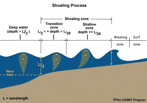
Deep sea, shoaling, and breaking zones.
However, these models cannot simply replace all previous models everywhere in the ocean: dispersive models are useless away from the shore and it is known that wave breaking cannot be simulated using Boussinesq-type equations. Hence the need to couple these models with others. Some work has been done in this direction with a multi-level nesting using software packages such as ROMS, but to the best of our knowledge, all the "boxes" rely on the same governing equations with different grid resolutions. A real coupling between different models is a more difficult task since different models may have different mathematical properties, as shown in the work by Eric Blayo and Antoine Rousseau on shallow water modelling 31.
Four year research objectives
Starting from the knowledge acquired in the collaboration with Eric Blayo on model coupling using domain decomposition techniques, our ambition is to propose theoretical and numerical tools in order to incorporate nearshore ocean models into large complex systems including several space and time scales. Two complementary research directions are considered:
- Dispersive vs non-dispersive shallow water models. As depicted in Figure 1 above, Boussinesq-type models (embedding dispersive effects) should be used in the so-called shoaling zone. The coupling with classical deep-sea / shallow water models has to be done such that all the processes in Figure 1 are correctly modelled (by different equations), with a reduced numerical cost. As a first guess, we think that Schwarz-type methods (widely used by the DDM community) could be good candidates, in particular when the interface locations are well-known. Moving interfaces (depending on the flow, the bathymetry and naturally the wind and all external forcings) is a more challenging objective that will be tackled after the first step (known interface) is achieved.
-
spectral vs time-domain models. In the context of mathematical modelling and numerical simulation for the marine energy, we want to build a coupled numerical model that would be able to simulate wave propagation in domains covering both off-shore regions, where spectral models are used, and nearshore regions, better described by nonlinear dispersive (Boussinesq-type) models.
While spectral models work with a statistical and phase-averaged description of the waves, solving the evolution of its energy spectrum, Boussinesq-type models are phase-resolving and solves nonlinear dispersive shallow water equations for physical variables (surface elevation and velocity) in the time domain. Furthermore, the time and space scales are very different: they are much larger in the case of spectral models, which justifies their use for modelling off-shore propagation over large time frames. Moreover, important small scale phenomena in nearshore areas are better captured by Boussinesq models, in which the time step is limited by the CFL condition.
From a mathematical and modelling point of view, this task mainly consists in working on the boundary conditions of each model, managing the simultaneous use of spectral and time series data, while studying transparent boundary conditions for the models and developing domain decomposition approaches to improve the exchange of information.
People
Antoine Rousseau, Joao Guilherme Caldas Steinstraesser
External collaborations
- Eric Blayo is the former scientific leader of team MOISE in Grenoble, where Antoine Rousseau was first recruited. Eric Blayo and Antoine Rousseau have co-advised 3 PhDs and continue to work together on coupling methods in hydrodynamics, especially in the framework of the COMODO ANR network.
- In the framework of its collaboration with MERIC, Antoine Rousseau and Joao Guilherme Caldas Steinstraesser collaborate with the consortium DiMe (ANR-FEM project), and more particularly with Jean-François Filipot ans Volker Roeber for the coupling of spectral and time-domain methods.
3.3.2 Data-model interactions
State of the Art
An alternative to direct observations is the chaining of numerical models, which for instance represent the physic from offshore to coastal areas. Typically, output data from atmospheric and ocean circulation models are used as forcings for a wave model, which in turn feeds a littoral model. In the case of extreme events, their numerical simulation from physical models is generally unreachable. This is due to a lack of knowledge on boundary conditions and on their physical reliability for such extreme quantities. Based on numerical simulated data, an alternative is to use statistical approaches. 36 proposed such an approach. They first produced and studied a 52-year hindcast using the WW3 wave model 35, 37, 34, 84. Then stemming from parts of the original work of 32, 53, 48, 36 proposed a semi-parametric approach which aims to simulate extreme space-time waves processes to, in turn, force a littoral hazard model. Nevertheless their approach allows only a very small number of scenarii to be simulated.
Four year research objectives
A first objective is to establish the link between the simulation approach proposed by 36 and the Pareto Processes 48. This will allow the work of 36 to be generalized, thus opening up the possibility of generating an infinity of extreme scenarii. While continuing to favor the semi- or non-parametric approaches made possible by the access to high spatial resolution calculations, we will try to capture the strength of potentially decreasing extremal dependence when moving towards higher values, which requires the development of models that allow for so-called asymptotic independence.
People
Gwladys Toulemonde, Antoine Rousseau
External collaborations
- since late 2019, LEMON has started a collaboration with IRT Saint-Exupéry on the hybridization of models and large amounts of data for the modelling of urban floods
- The collaboration with Romain Chailan (IMAG, UM, CNRS) and Frédéric Bouchette (Geosciences, UM) started in 2012 during the PhD of Romain entitled Application of scientific computing and statistical analysis to address coastal hazards.
- During her post doctoral position, Fátima Palacios Rodríguez with her co-advisors will consider a generalization of the proposed simulation method by 36.
3.4 Methodological developments
In addition to the application-driven sections, the team also works on the following theoretical questions. They are clearly connected to the above-mentioned scientific issues but do not correspond to a specific application or process.
3.4.1 Stochastic models for extreme events
State of the Art
Max-stable random fields 79, 78, 62, 42, 70 are the natural limit models for spatial maximum data and have spawned a very rich literature. An overview of typical approaches to modelling maxima is due to 44. Physical interpretation of simulated data from such models can be discussed. An alternative to the max-stable framework are models for threshold exceedances. Processes called GPD processes, which appear as a generalization of the univariate formalism of the high thresholds exceeding a threshold based on the GPD, have been proposed 48, 83. Strong advantages of these thresholding techniques are their capability to exploit more information from the data and explicitly model the original event data. However, the asymptotic dependence stability in these limiting processes for maximum and threshold exceedance tends to be overly restrictive when asymptotic dependence strength decreases at high levels and may ultimately vanish in the case of asymptotic independence. Such behaviours appear to be characteristic for many real-world data sets such as precipitation fields 43, 82. This has motivated the development of more flexible dependence models such as max-mixtures of max-stable and asymptotically independent processes 89, 27 for maxima data, and Gaussian scale mixture processes 71, 61 for threshold exceedances. These models can accommodate asymptotic dependence, asymptotic independence and Gaussian dependence with a smooth transition. Extreme events also generally present a temporal dependence 85 . Developing flexible space-time models for extremes is crucial for characterizing the temporal persistence of extreme events spanning several time steps; such models are important for short-term prediction in applications such as the forecasting of wind power and for extreme event scenario generators providing inputs to impact models, for instance in hydrology and agriculture. Currently, only few models are available from the statistical literature (see for instance 40, 41, 60) and remain difficult to interpret.
Four year research objectives
The objective is to extend state-of-the-art methodology with respect to three important aspects: 1) adapting well-studied spatial modelling techniques for extreme events based on asymptotically justified models for threshold exceedances to the space-time setup; 2) replacing restrictive parametric dependence modelling by semiparametric or nonparametric approaches; 3) proposing more flexible spatial models in terms of asymmetry or in terms of dependence. This means being able to capture the strength of potentially decreasing extremal dependence when moving towards higher values, which requires developing models that allow for so-called asymptotic independence.
People
Gwladys Toulemonde
External collaborations
In a natural way, the Cerise and Fraise project members are the main collaborators for developing and studying new stochastic models for extremes.
- More specifically, research with Jean-Noel Bacro (IMAG, UM), Carlo Gaetan (DAIS, Italy) and Thomas Opitz (BioSP, MIA, INRAE) focuses on relaxing dependence hypothesis.
- The asymmetry issue and generalization of some Copula-based models are studied with Julie Carreau (IRD, HydroSciences, UM).
3.4.2 Integrating heterogeneous data
State of the Art
Assuming that a given hydrodynamic models is deemed to perform satisfactorily, this is far from being sufficient for its practical application. Accurate information is required concerning the overall geometry of the area under study and model parametrization is a necessary step towards the operational use. When large areas are considered, data acquisition may turn out prohibitive in terms of cost and time, not to mention the fact that information is sometimes not accessible directly on the field. To give but one example, how can the roughness of an underground sewer pipe be measured? A strategy should be established to benefit from all the possible sources of information in order to gather data into a geographical database, along with confidence indexes.
The assumption is made that even hardly accessible information often exists. This stems from the increasing availability of remote-sensing data, to the crowd-sourcing of geographical databases, including the inexhaustible source of information provided by the Internet. However, information remains quite fragmented and stored in various formats: images, vector shapes, texts, etc.
This path of research begun with the Cart'Eaux project (2015-2018), that aims to produce regular and complete mapping of urban wastewater system. Contrary to drinkable water networks, the knowledge of sewer pipe location is not straightforward, even in developed countries. Over the past century, it was common practice for public service providers to install, operate and repair their networks separately 75. Now local authorities are confronted with the task of combining data produced by different parts, having distinct formats, variable precision and granularity 38.
Four year research objectives
The overall objective of this research line is to develop methodologies to gather various types of data in the aim of producing an accurate mapping of the studied systems for hydrodynamics models.
Concerning wastewater networks, the methodology applied consists in inferring the shape of the network from a partial dataset of manhole covers that can be detected from aerial images 7439. Since manhole covers positions are expected to be known with low accuracy (positional uncertainty, detection errors), a stochastic algorithm is set up to provide a set of probable network geometries 33. As more information is required for hydraulic modelling than the simple mapping of the network (slopes, diameters, materials, etc.), text mining techniques such as used in 63 are particularly interesting to extract characteristics from data posted on the Web or available through governmental or specific databases. Using an appropriate keyword list, thematic entities are identified and linked to the surrounding spatial and temporal entities in order to ease the burden of data collection. It is clear at this stage that obtaining numerical values on specific pipes will be challenging. Thus, when no information is found, decision rules will be used to assign acceptable numerical values to enable the final hydraulic modelling.
In any case, the confidence associated to each piece of data, be it directly measured or reached from a roundabout route, should be assessed and taken into account in the modelling process. This can be done by generating a set of probable inputs (geometry, boundary conditions, forcing, etc.) yielding simulation results along with the associated uncertainty.
Combining heterogeneous data for a better knowledge of studied systems raises the question of data fusion. What is the reality when contradictory information is collected from different sources? Dealing with spatial information, offset are quite frequent between different geographical data layers; pattern comparison approaches should be developed to judge whether two pieces of information represented by two elements close to each other are in reality identical, complementary, or contradictory.
People
Carole Delenne, Vincent Guinot, Antoine Rousseau, Gwladys Toulemonde
External collaborations
The Cart'Eaux project has been a lever to develop a collaboration with Berger-Levrault company and several multidisciplinary collaborations for image treatment (LIRMM), text analysis (LIRMM and TETIS) and network cartography (LISAH, IFSTTAR).
- The MeDo project lead by N. Chahinian (HSM) in collaboration with linguists of UMR Praxiling, uses data mining and text analysis approaches to retrieve information on wastewater networks from the Web. Carole Delenne has a slight implication in this project, as domain expert to guide the text annotations and for the uncertainties definition and representation in the mapping of the data collected.
- Concerning geographical data fusion for the wastewater network cartograhpy, the Phd thesis of Yassine Bel-Ghaddar has been funded by the French Association of Research and Technology (ANRT) in collaboration with Berger-Levrault company and in co-direction with A. Begdouri (LSIA Fès, Morocco).
3.4.3 Numerical methods for porosity models
State of the Art
Porosity-based shallow water models are governed by hyperbolic systems of conservation laws. The most widespread method used to solve such systems is the finite volume approach. The fluxes are computed by solving Riemann problems at the cell interfaces. This requires that the wave propagation properties stemming from the governing equations be known with sufficient accuracy. Most porosity models, however, are governed by non-standard hyperbolic systems.
Firstly, the most recently developed Dual Integral Porosity (DIP) models include a momentum source term involving the divergence of the momentum fluxes 58. This source term is not active in all situations but takes effect only when positive waves are involved 55, 56. The consequence is a discontinuous flux tensor and discontinuous wave propagation properties. The consequences of this on the existence and uniqueness of solutions to initial value problems (especially the Riemann problem) are not known, or are the consequences on the accuracy of the numerical methods used to solve this new type of equations.
Secondly, most applications of these models involve anisotropic porosity fields 64, 77. Such anisotropy can be modelled using porosity tensors, with principal directions that are not aligned with those of the Riemann problems in two dimensions of space. The solution of such Riemann problems has not been investigated yet. Moreover, the governing equations not being invariant by rotation, their solution on unstructured grids is not straightforward.
Thirdly, the Riemann-based, finite volume solution of the governing equations require that the Riemann problem be solved in the presence of a porosity discontinuity. While recent work 47 has addressed the issue for the single porosity equations, similar work remains to be done for integral- and multiple porosity-based models.
Four year research objectives
The four year research objectives are the following:
- investigate the properties of the analytical solutions of the Riemann problem for a continuous, anisotropic porosity field,
- extend the properties of such analytical solutions to discontinuous porosity fields,
- derive accurate and CPU-efficient approximate Riemann solvers for the solution of the conservation form of the porosity equations.
People
Vincent Guinot, Pascal Finaud-Guyot
External collaborations
Owing to the limited staff of the LEMON team, external collaborations will be sought with researchers in applied mathematics. Examples of researchers working in the field are
- Minh Le, Saint Venant laboratory, Chatou (France): numerical methods for shallow water flows, experience with the 2D, finite element/finte volume-based Telemac2D system.
- M.E. Vazquez-Cendon, Univ. Santiago da Compostela (Spain): finite volume methods for shallow water hydrodynamics and transport, developed Riemann solvers for the single porosity equations.
- A. Ferrari, R. Vacondio, S. Dazzi, P. Mignosa, Univ. Parma (Italy): applied mathematics, Riemann solvers for the single porosity equations.
- O. Delestre, Univ. Nice-Sophia Antipolis (France): development of numerical methods for shallow water flows (source term treatment, etc.)
- F. Benkhaldoun, Univ. Paris 13 (France): development of Riemann solvers for the porous shallow water equations.
.
4 Application domains
4.1 Overview
The protection of coastal areas around the world has become an important issue of concern, including within the scientific community. The coastline is defined as the physical separation between the sea or ocean on the one hand and the inland on the other, but these two worlds are in fact intertwined, which contributes to the difficulty of their modelling, both from a physical and statistical point of view.
4.2 Coastal Oceanography
Wave propagation models in the nearshore zone have evolved significantly over the last 15 years, with contributions that increasingly take into account effects related to variations of bathymetry, hence the non-hydrostatic nature of the flow. These models, very specific to the coastal zone, must be able to be coupled (together and with external models) so as to allow wave propagation numerical models to be integrated into numerical forecasting platforms, both in oceanography and in flood risk management.
4.3 Urban Floods
Due to climate change and rising sea levels, more and more cities are facing the risk of flooding. Whether they are in coastal areas or near rivers, these areas, which are inherently highly artificial and therefore poorly resistant to rising water levels, require different types of numerical models for flood risk: accurate (and potentially costly) models for land use planning, but also fast models, which can be run in real time, for crisis management.
4.4 Hasard and Risk Assessment
Modelling and risk assessment are at the heart of coastal science. Whether the events considered are of natural or anthropogenic origin, their economic, ecological or human impacts are too important to be neglected. By definition, the more extreme an event is, the lower its frequency of occurrence and therefore the less data available to characterize it. Hence the importance of using statistical tools dedicated to the modelling of extreme events, in order to provide risk management tools that are as safe and effective as possible.
4.5 Sustainable Energies
Renewable energies are an essential complement to energy sobriety and efficiency to offer a carbon neutral world. In coastal areas, energy can be captured from tide and currents or thanks to wind turbines, which can be installed both inland and at sea (floating or not). In order to optimise the location of the turbines (whatever they are) with regard to the power produced, two ingredients are essential and require very precise models: a knowledge of the resource on a fine scale as well as the control of the wake effect when we are interested in wind or tidal turbine farms.
5 Social and environmental responsibility
5.1 Footprint of research activities
Given the sanitary conditions endured throughout the year, we did not carry out any professional missions in 2020. Even students from South America did not have the opportunity to return to their families in the summer or during the holiday season.
Like all Inria teams, the many calculations we perform (on our personal computers or on dedicated clusters) do have an environmental cost. This cost is linked both to the resources needed to manufacture the machines we use, and to the energy consumed to run them.
This is why, in accordance with the recommendations of the "Labo 1.5" national initiative, we apply the 5-year rule for the renewal of our computers. In addition, we try to promote energy-efficient algorithms, such as porosity shallow water models, which reduce the computational (and therefore environmental) cost of our numerical simulations by several orders of magnitude.
Lemon members are aware of the climate emergency and are participating in actions on this subject. For example, Cécile Choley has been a "delegate for climate" and has represented French youth to COP2019 and COP2020, Pascal Finaud-Guyot is involved in the "sustainable development and social responsability" working group at Polytech and in "energy footprint reduction" working group at HSM with Carole Delenne.
5.2 Impact of research results
Our research activities have a twofold impact in terms of environmental responsibility:
- the research carried out in the field of renewable energy contributes to the increase of decarbonized energy (especially through the team's activities in Chile, in collaboration with the MERIC center of excellence).
- in addition, given the climate change already underway, the team's work in environmental risk assessment and management contributes to better anticipation of natural hasards which, unfortunately, will continue to occur in the coming decades.
6 Highlights of the year
As for many teams, the year 2020 was very special given the health context. During the periods of confinement, every member of the team managed its daily life as best as he/she could, with different constraints depending on each person's family situation.
Nevertheless, 2020 was marked by solid progress in the development of our SW2D platform, thanks to the commitment of Inria's technical team (SED@Sophia) and the hard work provided by the team, especially during the periods of confinement and teleworking. This year, we have completely reviewed the core of the C++ code and were able to propose a first functional version of the software under Linux, MacOS and Windows with the possibility to install the software via the sources or through precompiled binaries.
7 New software and platforms
7.1 New software
7.1.1 SW2D-Lemon
- Name: Shallow Water 2D - Lemon C++ software
- Keywords: Numerical simulations, Shallow water equations, Upscaling, Finite volume methods
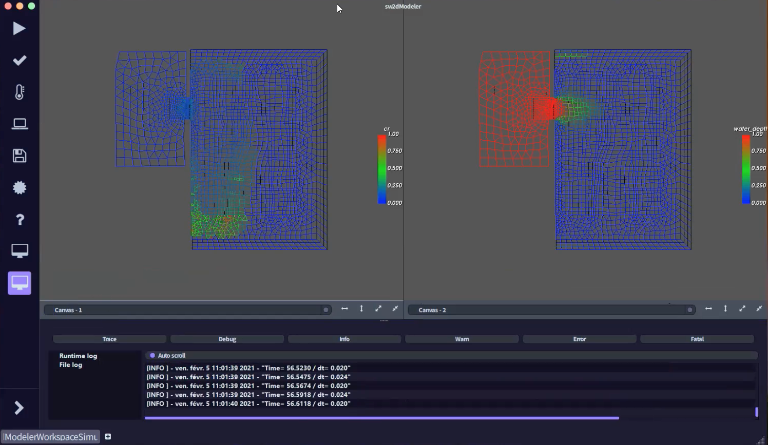
- Functional Description: An alternative approach consists in upscaling the shallow water equations using averaging techniques. This leads to introducing storage and conveyance porosities, as well as additional source terms, in the mass and momentum balance equations. Various versions of porosity-based shallow water models have been proposed in the literature. The Shallow Water 2 Dimensions (SW2D) computational code embeds various finite volume discretizations of these models. Ituses fully unstructured meshes with arbitrary numbers of edges. The key features of the models and numerical techniques embedded in SW2D are : - specific momentum/energy dissipation models that are active only under transient conditions. Such models, that are not present in classical shallow water models, stem from the upscaling of the shallow water equations and prove essential in modeling the features of fast urban flow transients accurately - modified HLLC solvers for an improved discretization of the momentum source terms stemming from porosity gradients - higher-order reconstruction techniques that allow for faster and more stable calculations in the presence of wetting/drying fronts.
- Release Contributions: - binary file for educational purposes (including documentation) first release - remove dependency with former package geo through mc.inria.fr ## version 0.8.1 - 04/02/2021 - now using dtk-forge (packages should be more homogeneous) (!220) - fixed frequency refresh for simulation (!246) - fixed using the control bar before finish breaking the results (!249) - fixed spurious call to close (!247) - added help menu (!238) - forbid loading settings during simulation (!244) ## version 0.8.0a - 28/01/2021 - logging now appears in the GUI sw2dModeler (!212) - you can extract values at chosen time using a dedicated text file (!217) - added various scripts and examples (!230 !229) - output file name changed (!224)
- News of the Year: In 2020, a large refactoring of the code has been made by the developer team. The new SW2D-LEMON code now includes single porosity, dual porosity and depth dependent porosity models. The graphical user interface has been widely improved and debugged. The 0.9.0 release is now available for training purposes in schools of engineers.
-
URL:
https://
sw2d. inria. fr/ - Authors: Vincent Guinot, Antoine Rousseau, Carole Delenne, Joao Guilherme Caldas Steinstraesser, Thibaud Kloczko, Tristan Cabel, Nicolas Niclausse, Jean-Luc Szpyrka, Ghada Bahloul, Pierre Fernique, Come Le Breton, Joseph Luis Kahn Casapia, Julien Wintz
- Contacts: Antoine Rousseau, Vincent Guinot, Carole Delenne, Pascal Finaud Guyot
- Partner: Université de Montpellier
8 New results
8.1 Inland flow processes
8.1.1 Endoreic waterbodies delineation from remote-sensing as a tool for immersed surface topography.
This path for research was initiated several years ago in collaboration with J. S. Bailly (LISAH). We recently came up with a methodology developed on synthetic data and submitted to Geosciences and Remote Sensing Letters25.
Since several decades, it becomes possible to delineate waterbodies and their dynamics from optical or radar images, that are now available at high spatial and temporal resolutions. We present here an interpolation approach that takes benefits from this waterbodies delineation which consist in endoreic areas, in isovalue contourlines to improve topography estimation classically obtained from measurement points only. The approach, based on a minimisation problem, uses Thin Plate Splin interpolation functions, whose coefficient are determined along with the unknown water level of each curve. Results obtained on a generated topography show that this approach, applied with three contour-line curves, yields a lower root mean square error with only one measurement point as the one obtained with nine points and the classical approach.
8.1.2 Forcing
A book chapter entitled Space-time simulations of extreme rainfall : why and how ? involving among others two members of the team, Vincent Guinot and Gwladys Toulemonde has been published 20 by Wiley in a book entitled Mathematical Modeling of Random and Deterministic Phenomena. This chapter aims to present practical interest of doing space-time simulations of extreme rainfall and to propose a state-of-art about that.
8.1.3 Hydraulic signature of flooded streets network
Understanding urban flood flow repartition mechanisms within streets network remains challenging. We propose an analysis of a dataset composed of water depth and velocity profiles measured in the Icube urban flood experimental rig. The spatial variability of discharge along a street is highlighted. Comparing the water depth gradient orientation and the flow repartition promotes for complex repartition mechanisms at small scales. Comparable unit-discharge values are observed in both large and narrow streets. Interestingly, the intensity of the discharge deviation at the crossroad scale is related with the asymmetry of the velocity profile entering a crossroad. Moreover, discharges both at the crossroad and the subdistrict scale show that downscaling of the flow repartition relationship is difficult. At real scale, results show that in flow velocity profile asymmetry may persist on a distance of several street widths downstream of a crossroad. Such distances are insufficient to consider disconnected crossroads as done in the literature to establish discharge repartition relationships.
This work has been published in Urban Water Journal 7.
8.2 Marine and coastal systems
8.2.1 Data-model interaction: space-time Pareto processes to generate scenarios for natural hasards
This novel approach is presented in this subsection but it is important to note that it also could has been presented in the subsection Forcing because the proposed method could be used as rainfall forcing and because it answers to some mentionned challenges. In order to assess the risks associated with destructive natural hasards, impact models can be fed with simulations of extreme scenarios for studying the sensitivity to temporal and spatial variability. Nevertheless, available data may be insufficient due to the sparse occurrence of extreme episodes. In 10, we introduce a methodology to stochastically simulate realistic spatio-temporal extreme fields. To this end, we use a moderate number of observed extreme space-time episodes to generate an unlimited number of extreme scenarios of any magnitude. The theoretical justification of our framework comes from extreme-value theory where generalized Pareto limit processes arise for threshold exceedances. We extend the results of 36 who generated wave heights and we illustrate the proposal on precipitation data in Mediterranean France.
8.2.2 Caracterizing geometrical structure of a living coral reef barrier
Based on a series of high-resolution seabottom elevation measurements along the Maupiti barrier reef, French Polynesia, we derive several statistical metrics and spectral analysis 12. They permit to characterize the spatial evolution of the coral geometrical structure from the reef crest to the backreef. A consistent fractal-like power law exists in the spectral density of bottom elevation for length-scales between 0.1 and 7m while, at larger scale, the reef structure shows a different pattern. Such a fine characterization of the reef geometrical structure provides key elements to reconstruct the reef history, to improve the representation of reef roughness in hydrodynamical models and to monitor the evolution of coral reef systems in the global change context.
8.3 Methodological developments
8.3.1 Stochastic models for extreme events
Hierarchical space-time modeling of exceedances
Again, this novel approach has been presented in the subsection Forcing because it answers to some related challenges.
The statistical modeling of space-time extremes in environmental applications is a valuable approach to understand complex dependencies in observed data and to generate realistic scenarios for impact models. Motivated by hourly rainfall data in Southern France presenting asymptotic independence, we propose in a joint work (J.N. Bacro, C. Gaetan, T. Opitz and G. Toulemonde) published in 2020 in the Journal of the ASA 3 a novel hierarchical model for high threshold exceedances leading to asymptotic independence in space and time. Our approach is based on representing a generalized Pareto distribution as a Gamma mixture of an exponential distribution, enabling us to keep marginal distributions which are coherent with univariate extreme value theory. The key idea is to use a kernel convolution of a space-time Gamma random process based on influence zones defined as cylinders with an ellipsoidal basis to generate anisotropic spatio-temporal dependence in exceedances. Statistical inference is based on a composite likelihood for the observed censored excesses. The practical usefulness of our model is illustrated on the previously mentionned hourly precipitation data set from a region in Southern France.
Extension of the XGumbel copula to the spatial framework
An extension of the XGumbel copula to the spatial framework has been developped. This work has been published in 2020 in Spatial Statistics 6. The XGumbel copula combines two Gumbel copulas with weight parameters, termed extra-parameters, taking values in the unit hyper-cube. In a multisite study, the copula dimension being the number of sites, the XGumbel copula quickly becomes over-parametrized. In addition, interpolation to ungauged locations is not easily achieved. We propose a spatial model for maxima that combines a spatial regression for GEV marginals and the spatialized XGumbel copula defined thanks to a spatial mapping for the extra-parameters. An Approximate Bayesian Computation (ABC) scheme that seeks to reproduce upper tail dependence coefficients for distance classes is used to infer the parameters. The extension of the XGumbel copula to the spatial framework has been used to study annual maxima of daily precipitation totals at 177 gauged stations over a 57 year period in the French Mediterranean.
8.3.2 Modified parareal method shallow water equations
In this work, submitted to SMAI Journal of Computational Mathematics 24 the POD-DEIM-based (Proper Orthogonal Decomposition-Discrete Empirical Interpolation Method) parareal method is implemented for the resolution of the two-dimensional nonlinear shallow water equations using a finite volume scheme. This method is a variant of the traditional parareal method, that improves the stability and convergence for nonlinear hyperbolic problems, and uses reduced-order models constructed via the POD-DEIM applied to snapshots of the solution of the parareal iterations. We propose a modification of this parareal method for further stability and convergence improvements. It consists in enriching the snapshots set for the POD-DEIM procedure with extra snapshots whose computation does not require any additional computational cost. The performances of the classical parareal method, the POD-DEIM-based parareal method and our proposed modification are compared using numerical tests with increasing complexity. Our modified method shows a more stable behaviour and converges in fewer iterations than the other two methods.
8.3.3 Identifying river flow characteristic from satellite observation
The development of satellite missions studying continental water surfaces provides an unprecedented and increasing potential for studying ungauged hydrological and hydraulic processes from their signatures, especially on complex flow zones. However, despite the variability of the available data (water surface elevation and slope, river width, ...), the discharge estimation requires an inverse problem that is generally ill-posed due to unknown bathymetry and friction in ungauged rivers.
In this context, we develop a forward and inverse modeling for anabranching river flows (using an effective 1D hydraulic modeling approach of sufficient complexity). Using altimetric water height timeseries (from sparse multisatellite observations), it is shown on 71km of the Xingu River (anabranching, Amazon basin) that a fairly accurate upstream discharge hydrograph and effective patterns of channel bathymetry and friction can be inferred simultaneously. The discharge hydrograph at observation times and effective bathymetry-friction patterns are retrieved from 8 years of satellite altimetry (ENVISAT) at 6 virtual stations (VS) along flow. The modeling approach is extended for distributed channel parameters and multiple inflows (in the 1D Saint-Venant model). On synthetic cases, the estimation of both inflows and distributed channel parameters (bathymetry-friction) is achievable with a minimum spatial observability between inflows as long as their hydraulic signature is sampled. Applicability of the method on 871 km of the Negro river (Amazon basin) including complex multichannel reaches, 21 tributaries and backwater controls from major confluences is also highlighted.
Moreover, a numerical analysis shows: (i) the importance of an unbiased prior information in the inference of a triplet from WS observations; (ii) the clear signatures of river bottom slope break in low flows and width variations in high flows through the analysis of the friction slope term. This study brings also insights in: (i) the hydraulic visibility of multiple inflows hydrographs signature at large scale with SWOT satellite; (ii) the simultaneous identifiability of spatially distributed channel parameters and inflows by assimilation of satellite altimetry data.
Two articles have been published in Journal of Hydrology 8, 11.
8.3.4 Downscaling of shallow water flows
We proposed a statistical method for downscaling the results of upscaled model simulations onto refined grids 5. The ultimate objective is to combine the rapidity of porosity models (up to times as fast as classical 2D shallow water models) with that of machine learning-based methods to achieve a high-resolution assessment of the flood hazard within urban areas. In this first phase of the research, perfect upscaling was considered: the results of a refined 2D simulation was averaged over a coarse porosity model grid. An algorithm involving Proper Orthogonal Decomposition and an Artificial Neural Network was trained to retrieve the high-resolution results from the coarse grid average. The next steps of the research will consist in using porosity model results (that provide imperfect upscaling) as inputs.
8.4 Other contributions
8.4.1 Soil moisture modeling in context of climate change
Soil moisture characterises agricultural droughts and plays a key role on runoff generation and thus on flood generation. Future soil moisture of the Mediterranean region is modelled under various climate scenarios to evaluate the impacts of changing precipitation patterns on extreme hydrological events such as droughts and floods.
This study focuses on 10 sites, located in southern France, with available soil moisture, temperature, and precipitation observations for a 10-year time period. Soil moisture is simulated at each site at the hourly time step using a model of soil water content. The sensitivity of the simulated soil moisture to different changes in precipitation and temperature is evaluated by simulating the soil moisture response to temperature and precipitation scenarios generated using a delta change method for temperature and a stochastic model (the Neyman–Scott rectangular pulse model) for precipitation.
Results show that soil moisture is more impacted by changes in precipitation intermittence than precipitation intensity and temperature. Overall, increased temperature and precipitation intensity associated with more intermittent precipitation leads to decreased soil moisture and an increase in the annual number of days with dry soil moisture conditions. In particular, a temperature increase of +4°C combined with a decrease of annual rainfall between 10% and 20%, corresponding to the current available climate scenarios for the Mediterranean, lead to a lengthening of the drought period from June to October with an average of +28days of soil moisture drought per year.
This work has been submitted in Hydrology and Earth System Sciences in 2020 and accepted in early 2021 9.
8.4.2 Coupling and reduction of hydro-ecological models for the simulation of freshwater aquatic ecosystems
Algal Bloom is a natural process of rapid population growth of cyanobacteria (a group of photosynthetic bacteria) in aquatic environments, this is a consequence of the artificial enrichment caused by human activity. Our main objective is to build a hydro-ecological model to understand the dynamics of cyanobacteria in aquatic environments, taking into account the various essential factors for its development.
In this work 19 we focus on the modelling of cyanobacteria dynamics. Light aside, the main growth limitations of cyanobacteria are phosphorus and nitrogen in their inorganic form. One of the main sources of phosphorus and nitrogen for the growth of cyanobacteria comes from rivers (external loading). But specific hydrodynamic conditions (wind, strong currents) lead to the resuspension of the sediment which provide a second source of phosphorus and nitrogen (internal loading), mainly in their organic form. One survival mechanism of cyanobacteria is the production of an enzyme that transforms the organic phosphorus into inorganic phosphorus when the concentration of inorganic phosphorus is low.
The coupled hydro-ecological model (SW2D-WASP) was applied on the study case of Lake Taihu in the framework of the French-Chinese ANSWER project funded by the ANR.
8.4.3 Modelling passive scalar transport in highly heterogeneous media
The purpose of this research 13 was to investigate passive scalar transport in highly heterogeneous media. Laboratory experiments were performed on dual conduit structures exhibiting a long flow path and a shortcut. Injecting concentration pulses resulted in double-peaked breakthrough curves, a phenomenon that is frequently observed with in situ pumping tests in fractured and/or karstified aquifers. A one-dimensional transport model with dual transport properties allowed the experimental breakthrough curves to be reproduced satisfactorily. Three parameters were investigated in the experimental study:(1) the length ratio between the two conduits for a fixed length of the shorter conduit, (2) the total length of the conduits for a fixed length ratio, (3) the connection angle between the conduits. A method was proposed to infer the karst conduit length from the experimental breaktrough curves. It is expected that the model validated in this study can be used in the future as an upscaled model for solute and sediment transport in upscaled flow models such as porosity models (see subsections 3.2.1).
9 Bilateral contracts and grants with industry
9.1 Bilateral Contracts with Industry
9.1.1 GERIMU
The GERIMU project entered its second phase in 2019. The industrial version of the SW2D computational code was parallelized and tested by ASA Company (subcontractor). Integration of all software components into the final software product took place in 2020.
9.1.2 IRT Saint-Exupéry
In late 2019, we started a new collaboration with IRT Saint-Exupéry for the hibridization of numerical models and large amount of data for the modeling of urban floods.
Financial difficulties and the health crisis unfortunately forced one of the partners to give up its participation, which necessitated a reformulation of the partnership project. The collaboration will only really start in 2021.
9.1.3 Berger-Levrault
A research collaboration convention was signed with Berger-Levrault company for three years, in the framework of Yassine Bel-Ghaddar thesis (CIFRE ANRT France/Maroc).
10 Partnerships and cooperations
10.1 International Initiatives
10.1.1 Inria International Partners
Informal International Partners
We traditionally have regular partnerships (including exchanges and visits) with foreign partners, notably in Chile, the USA, Canada and Belgium. In the context of the current crisis, these partnerships have been put on hold for 2020.
A research collaboration agreement was signed with LSIA, Fès University, Morocco in the frame- work of Yassine Bel-Ghaddar PhD thesis.
10.1.2 Participation in other International Programs
- Vincent Guinot and Pascal Finaud-Guyot are members of the Naïla Laboratoire Mixte International (LMI). Naïla is an international research program in partnership with Tunisia. The research and application domains are the management of water and resources in agricultural hydrosystems.
- Gwladys Toulemonde is member of the PHC Utique project (with Tunisia) AMANDE (PI Julie Carreau, IRD), 2019-2021. The project AMANDE focuses on stochastic and semi-parametric approaches combined to remote sensing for the study of the water stress.
10.2 European Initiatives
10.2.1 Collaborations in European Programs, except FP7 and H2020
- Carole Delenne is member of the CASCADE Project (PI Renaud Hostache, LIST) funded by the Luxembourg National Research Fund, which aims to combine earth observation with a large scale model cascade for assessing flood hazard at high spatial resolution.
10.3 National Initiatives
ANR Projects
-
Antoine Rousseau is member of the ANR project ANSWER (PI Céline Casenave), 2016-2021. In this Franco-Chinese collaborative project, researchers from different fields are working to develop an integrative platform for modelling lake ecosystems; this platform includes data management and knowledge representation tools, new models and new analysis methods.
The project, which was originally scheduled to end in 2020, has been extended by one year due to the COVID-19 crisis.
- Pascal Finaud-Guyot is member of the ANR project DEUFI (PI André Paquier, INRAE Lyon), 2019-2022. This project focuses on street-buildings exchanges during flood event. Such phenomenons are frequently ignored in operational flood models. The objective is thus to (i) develop approaches allowing to take into account those phenomenon, (ii) identify the combinations of urban geometry and flood characteristics for which those phenomenon cannot be neglected and (iii) propose operational modelling methodology corresponding to a trade-off between precision, computational cost and data availability. This project funds the PhD thesis of Cécile Choley.
- Gwladys Toulemonde is member of the ANR project Gambas (PI Frédéric Mortier, Cirad), 2019-2023. The project GAMBAS focuses on joint species distribution models. These models can provide a better understanding and more accurate predictions of species distributions based on environmental variables while taking into account the effects of all other co-occurring species (e.g. competition).
- Gwladys Toulemonde is member of the ANR project McLaren (PI Thomas Laloé, Université Côte d'Azur), 2020-2024. The project McLaren focuses on Machine Learning and risk evaluation.
Other national initiatives
- Gwladys Toulemonde is head of a project (2019-2021) funded by INSU via the action MANU (MAthematical and NUmerical methods) of the LEFE program. This project, called Fraise, is focused on rainfall forcing by stochastic simulation for hydrological impact studies from dry periods to extreme events. The consortium involved in this project is larger than the Cerise one (14 researchers from 8 partners : AgroParisTech, CNRS, INRAE, Inria, IRD, Université de Lyon 1, Université de Montpellier and the University of Venise in Italy).
- All the team is involved in the Inria ADT named SW2D-Lemon (see Section 7.1. This development project led to 2 coding sprints (of 2 weeks each) with the development team in Sophia and to important developments achieved by the permanent members of LEMON during the different sanitary confinement periods. Thanks to this project, SW2D is now a C++ platform, with a dedicate GUI.
- Several members of LEMON are involved in the Inria Challenge SURF (Sea Uncertainty Representation and Forecast). The activity has been reduced in 2020 and the program should really start in early 2021, with one PhD recruitment co-advised between the LEMON and CARDAMOM project-teams.
10.4 Regional Initiatives
The MeDo project (lead by N. Chahinian) in which Carole Delenne participates is funded by Occitanie Region.
11 Dissemination
11.1 Promoting Scientific Activities
11.1.1 Scientific Events: Selection
Member of the Conference Program Committees
- Gwladys Toulemonde is member of the scientific committee of the JdS (Journées de Statistique) 2020.
11.1.2 Journal
Member of the Editorial Boards
- Gwladys Toulemonde is guest editor of a special issue of the Journal Spatial Statistics entitled Space-time modeling of rare events and environmental risks, 2020. This special issue is related to the conference METMA 9 organized in 2018 in Montpellier by Gwladys Toulemonde and Liliane Bel.
- Antoine Rousseau is associate editor of DSDS-S.
Reviewer - Reviewing Activities
- Carole Delenne is a reviewer for Journal of Hydrology, Journal of Hydraulic Research, Water, Computers Environment and Urban Systems... (1 to 3 manuscripts/year)
- Vincent Guinot is a reviewer for Journal of Hydrology, Advances in Water Resources, Mathematical Problems in Engineering (3 manuscripts/year)
- Antoine Rousseau is a reviewer for Journal of Hydrology and Environmental Modeling & Assessment (2 manuscripts/year) and Mathematical Modelling and Numerical Analysis (ESAIM: M2AN, 1 manuscript/year)
- Pascal Finaud-Guyot is a reviewer for Journal of Hydroinformatics, Advances in Water Resources, Environmental Modelling and Software, Journal of Hydrology (2 manuscripts/year)
- Gwladys Toulemonde is a reviewer for Annals of applied statistics, Computational statistics and data analysis, Dependence modeling, Extremes, Journal of applied Statistics, Journal of Statistical Theory and Practice, Statistics and Computing, Water Ressources research (1 to 3 manuscripts/year)
11.1.3 Invited Talks
Invited talk in a session Climate Extremes of the ERCIM-CMStatistics conference in December, 2020 (Virtual event). E493: Space-time extreme simulations for natural disasters.
11.1.4 Scientific Expertise
- Antoine Rousseau is member of the scientific board of Fondation Blaise Pascal
- Gwladys Toulemonde is appointed by the Occitanie region to the scientific board in charge of innovation projects in the field of intelligent systems and digital data chain
- Antoine Rousseau is member of the international scientific board of the Climat-AmSud program
11.1.5 Research Administration
- Vincent Guinot is head of the "Eau dans la Ville" cross-disciplinary research group at HSM (20 staff members) and of the Urban Observatory of HSM,
- Vincent Guinot is a member of the board for scientific strategy at HSM,
- Carole Delenne is elected member of the HSM board (UMR 5569),
- Antoine Rousseau is head of the LEMON team at Inria CRI-SAM (5 staff members),
- Antoine Rousseau is a member of the Inria CRI-SAM steering board (Comité des Projets)
- Antoine Rousseau is a member of the Inria CRI-SAM scientific board (Bureau du Comité des Projets)
- Gwladys Toulemonde is elected member of the IMAG board (UMR 5149)
- Gwladys Toulemonde is elected member of the MIPS Scientific Department (Mathematics, Computer Science, Physics and Systems), a component of the University of Montpellier
- Gwladys Toulemonde is vice-president of the French Statistical Society (Société Française de Statistique, SFdS)
- Gwladys Toulemonde is elected member of the French Statistical Society board (Société Française de Statistique, SFdS)
- Gwladys Toulemonde is elected member of Environment group of the French Statistical Society board (Société Française de Statistique, SFdS)
- Gwladys Toulemonde is elected member of the liaison commitee of the MAS Group (Modélisation Aléatoire et Statistique), SMAI (Société de Mathématiques Appliquées et Industrielles)
11.2 Teaching - Supervision - Juries
Teaching
Four LEMON permanent members (out of five) are university staff and have teaching duties. Most of their lectures are given at master level at Polytech Montpellier in the departments Informatics and Management (IG), Water Sciences and Technologies (STE) and Water and Civil Engineering (EGC) as well as in other courses of University of Montpellier. The teaching load is summarized in Table 1.
Moreover:
- Gwladys Toulemonde is responsible for student recruitment at the IG and DO departments (Polytech Montpellier).
- Carole Delenne is in delegation Inria from September 1rst, 2020 to August 31srt, 2021.
- Gwladys Toulemonde was in delegation Inria from March 1rst, 2020 to August 31srt, 2020.
- Joao Guilherme Caldas Steinstraesser did the following teaching at University of Montpellier, Department of Mechanics of the Faculty of Sciences (Méca-FDS) and Polytech Montpellier:
- Modelling and conception of mechanical systems (Méca-FDS L1, TD, 24h);
- Dynamics of mechanical systems (Méca-FDS L2, TD, 18,5h);
- Mathematical modelling in Mechanics (Méca-FDS L3 and Polytech - first year, TP, 18h);
- Cécile Choley tought hydraulics "TP" at STE department of Polytech Montpellier, 2x30h.
- Yassine Bel-Ghaddar did the following teaching at Fes University (USMBA):
- "Systèmes d'Information et Bases de Données", M2, TD, 2x18h.
- "Bases de données", M1, TD, 1x18h.
| Antoine Rousseau | Teaching M1 level: 0 to 30 hrs/year |
| Student supervision: 50 hrs/year | |
| Carole Delenne (except delegation) | Teaching L1-M2 level: 200-250 hrs/year |
| hydraulics, applied mathematics, informatics | |
| Student tutorship and supervision: 50-100 hrs/year | |
| Gwladys Toulemonde | 50 Inria delegation in 2019/2020 |
| Teaching L3/M1/M2 level: 150 hrs in 2020 | |
| mathematics, probability, statistics, data mining | |
| Pascal Finaud-Guyot | Teaching L3/M1/M2 level: 200-250 hrs/year |
| hydraulics, applied mathematics, informatics | |
| Student tutorship and supervision: 50-100 hrs/year | |
| Vincent Guinot | Teaching L3/M1/M2 level: 290 hrs/year |
| Student tutorship and supervision: 50-100 hrs/year |
Supervision
- PhD in progress :
- Vita Ayoub, "Assimilation of satellite derived flood information for better parameterizing and controlling large scale hydraulic models over data scarse areas", november 2018, Carole Delenneand R. Hostache (LIST, Luxembourg).
- Yassine Bel-Ghaddar, "Data fusion for urban network mapping. Application to sanitation networks", may 2019, Carole Delenneand A. Begdouri (LSIA, Fès, Morocco).
- Joseph Luis Kahn Casapia, "Coupling hydro-ecological reduced models for the simulation of fresh water ecosystems", September 2018, Antoine Rousseau and C. Casenave (INRAE, Montpellier).
- Joao Guilherme Caldas Steinstraesser, "Coupling large and small scale shallow water models with porosity in the presence of anisotropy", October 2019, Antoine Rousseau and Vincent Guinot.
- Cécile Choley, "Experimental an numerical study of the street-building exchange during urban floods", November 2019, Pascal Finaud-Guyot.
Juries
- Gwladys Toulemonde has participated to the PhD thesis jury of Marine Demangeot defended in October 2020 at École des Mines, Paris.
11.3 Popularization
11.3.1 Internal or external Inria responsibilities
- Gwladys Toulemonde is involved in the board of the CFEM (commission française pour l'enseignement des mathématiques) since october, 2019, representing the SFdS.
- Gwladys Toulemonde is involved in the board of Animath since october, 2019, representing the SFdS.
- Gwladys Toulemonde is a member of the organizing committee of the Forum Emploi Math (FEM 2020, virtual event).
- Gwladys Toulemonde is a member of the organizing committee of the Salon de la culture et des jeux mathématiques, 2020.
- Antoine Rousseau is member of the scientific board of Fondation Blaise Pascal
- Antoine Rousseau is co-editor of the national blog binaire, published by Le Monde
- Antoine Rousseau was editor of the national initiative "Calendrier Mathématique" 2020 (texts by Serge Abiteboul and Charlotte Truchet)
11.3.2 Interventions
- Antoine Rousseau gave a lecture "Tsunamilab, une plateforme numérique interactive pour créer des tsunamis" at the (online) event "European Researchers' Night" 2020.
- Antoine Rousseau gave a lecture "Immersion au coeur d'un tsunami" at the national (online) event "Fête de la Science" 2020.
- Cécile Choley gave a lecture with Julie Vereecke (DREAL) Inondations : quels rôles pour l'Etat et les chercheurs ? at the national (online) event "Fête de la Science" 2020.
- Cécile Choley and Antoine Rousseau gave a conference at Salon de la Culture et des Jeux Mathématiques (May 2020): "Des maths pour quantifier et limiter les incertitudes sur les modèles climatiques"
12 Scientific production
12.1 Major publications
- 1 articleFlux closures and source term models for shallow water models with depth-dependent integral porosityAdvances in Water Resources122September 2018, 1-26
12.2 Publications of the year
International journals
International peer-reviewed conferences
Conferences without proceedings
Scientific book chapters
Doctoral dissertations and habilitation theses
Reports & preprints
12.3 Cited publications
- 27 articleA flexible dependence model for spatial extremesJournal of Statistical Planning and Inference1722016, 36--52
- 28 articleModelling of biological decontamination of a water resource in natural environment and related feedback strategiesJournal of Scientific Computing68(3)2016, 1267-1280
- 29 articleA spatiotemporal precipitation generator based on a censored latent Gaussian fieldWater Resour. Res.512015, 4338-4358
- 30 articleParalic confinement computations in coastal environment with interlocked areasDiscrete and Continuous Dynamical Systems - Series S81February 2015, 45-54
- 31 articleAbout Interface Conditions for Coupling Hydrostatic and Nonhydrostatic Navier-Stokes FlowsDiscrete and Continuous Dynamical Systems - Series S2015, 10
- 32 techreport On the determination of the temporal and spatial evolution of extreme events report 1202120-001-HYE-004 (for Rijkswaterstaat, Centre for Water Management) Deltares 2011
- 33 articleAutomatic mapping of urban wastewater networks based on manhole cover locationsComputers, Environment and Urban Systems782019, 101370
- 34 phdthesis Application of Scientific Computing and Statistical Analysis to Address Coastal Hazards University of Montpellier 2015
- 35 inproceedingsHigh performance pre-computing: Prototype application to a coastal flooding decision toolKnowledge and Systems Engineering (KSE), 2012 Fourth International Conference onIEEE2012, 195--202
- 36 articleA semiparametric method to simulate bivariate space--time extremesAnn. Appl. Stat.1132017, 1403--1428URL: https://doi.org/10.1214/17-AOAS1031
- 37 articleSpatial assessment of extreme significant waves heights in the Gulf of LionsCoastal Engineering Proceedings1342014, 17
- 38 inproceedingsBuried Utility Pipeline Mapping Based on Multiple Spatial Data Sources: A Bayesian Data Fusion ApproachIJCAI-11, Barcelona, Spain2011, 2411-2417
- 39 inproceedingsManhole cover localization in aerial images with a deep learning approachInt. Arch. Photogramm. Remote Sens. Spat. Inf. Sci., ISPRS Work. HanoverXLII-1/W12017, 333--338
- 40 articleMax-stable processes for modeling extremes observed in space and timeJournal of the Korean Statistical Society422013, 399--414
- 41 articleStatistical inference for max-stable processes in space and timeJournal of the Royal Statistical Society752013, 791--819
- 42 articleGeostatistics of extremesProceedings of the Royal Society London, Series A4682012, 581-608
- 43 articleGeostatistics of dependent and asymptotically independent extremesJournal of Mathematical Geosciences452013, 511--529
- 44 articleStatistical modelling of spatial extremesStatistical Science272012, 161-186
- 45 articleTwo-dimensional shallow flow equations for partially dry areasWater Resour. Res.36112000, 3251URL: http://dx.doi.org/10.1029/2000WR900167
- 46 inproceedings Combining punctual and ordinal contour data for accurate floodplain topography mapping (poster and 8p. paper) Spatial accuracy: International symposium on Spatial Accuracy Assessment in Natural Resources and Environmental Sciences Montpellier (France) 07 2016
- 47 articleA 1D–2D Shallow Water Equations solver for discontinuous porosity field based on a Generalized Riemann ProblemAdv. Water Resour.1072017, 233-249URL: http://dx.doi.org/10.1016/j.advwatres.2017.06.023
- 48 articleThe generalized Pareto process; with a view towards application and simulationBernoulli2042014, 1717--1737URL: https://doi.org/10.3150/13-BEJ538
- 49 article A flexible dependence model for spatial extremes Limnol. Oceanogr. 1997
- 50 articleParalic Confinement: Models and SimulationsActa Appl Math1231January 2013, 1--19
- 51 articleProbabilistic flood mapping using synthetic aperture radar dataIEEE Trans. Geosci. Remote Sens.54122016, 6958-6969
- 52 articleA derivation of equations for wave propagation in water of variable depthJ. Fluid Mech.21976, 237--246
- 53 articleTemporal and Spatial Evolution of Extreme EventsCoastal Engineering Proceedings1332012, 9
- 54 articleMacroscopic modelling of urban floodsLa Houille Blanche62014, 19--25
- 55 articleMultiple porosity shallow water models for macroscopic modelling of urban floodsAdv. Water Resour.372012, 40--72URL: http://dx.doi.org/10.1016/j.advwatres.2011.11.002
- 56 article A critical assessment of flux and source term closures in shallow water models with porosity for urban flood simulationsAdvances in Water Resources1092017, 133-157
- 57 article Consistency and bicharacteristic analysis of integral porosity shallow water models. Explaining model oversensitivity to grid designAdvances in Water Resources1072017, 34-55
- 58 articleDual integral porosity shallow water model for urban flood modellingAdvances in Water Resources1032017, 16-31
- 59 articleFlux and source term discretization in two-dimensional shallow water models with porosity on unstructured gridsInt. J. Numer. Methods Fluids5032006, 309--345URL: http://dx.doi.org/10.1002/fld.1059
- 60 articleSpace-time modelling of extreme eventsJournal of the Royal Statistical Society: Series B762014, 439--461
- 61 articleBridging asymptotic independence and dependence in spatial extremes using Gaussian scale mixturesSpat. Stat.21part A2017, 166--186URL: https://doi.org/10.1016/j.spasta.2017.06.004
- 62 articleStationary max-stable fields associated to negative definite functionsThe Annals of Probability2009, 2042--2065
- 63 inproceedingsWhen Textual Information Becomes Spatial Information Compatible with Satellite ImagesKDIR2015, 301-306
- 64 articleUrban flood modeling with porous shallow-water equations: A case study of model errors in the presence of anisotropic porosityJ. Hydrol.5232015, 680--692URL: http://dx.doi.org/10.1016/j.jhydrol.2015.01.059
- 65 article Derivation of asymptotic two-dimensional time-dependent equations for surface water wave propagation Physics of Fluids 21 016601 doi:10.1063/1.3053183 2009
- 66 articleSpace-time simulation of intermittent rainfall with prescribed advection field: Adaptation of the turning band methodWater Resources Research49(6)2013, 3375-3387
- 67 articleNew Developments and Cosine Effect in the Viscous Shallow Water and Quasi-Geostrophic EquationsMultiscale Modeling and Simulations722008, 793--813URL: http://hal.inria.fr/inria-00180921
- 69 articleDecadal monitoring of the Niger Inner Delta flood dynamics using MODIS optical dataJournal of Hydrology5232015, 358-383URL: http://dx.doi.org/10.1016/j.jhydrol.2015.01.036
-
70
articleExtremal
processes: elliptical domain of attraction and a spectral representation'J. Multivariate Anal.1222013, 409--413URL: https://doi.org/10.1016/j.jmva.2013.08.008 - 71 articleModeling asymptotically independent spatial extremes based on Laplace random fieldsSpat. Stat.162016, 1--18URL: https://doi.org/10.1016/j.spasta.2016.01.001
- 72 articleShallow water equations with depth-dependent anisotropic porosity for subgrid-scale topographyAppl. Math. Model.4017-182016, 7447--7473URL: http://dx.doi.org/10.1016/j.apm.2015.12.012
- 73 articleUrban flood modeling using shallow water equations with depth-dependent anisotropic porosityJ. Hydrol.5412016, 1165--1184URL: http://dx.doi.org/10.1016/j.jhydrol.2016.08.025
- 74 articleDetection of manhole covers in high-resolution aerial images of urban areas by combining two methodsIEEE J. Sel. Top. Appl. earth Obs. Remote Sens.952016, 1802--1807URL: http://dx.doi.org/10.1109/JSTARS.2015.2504401
- 75 articleCondition assessment of the buried utility service infrastructure: a proposal for integrationTunnelling and Underground Space Technology282012, 202-211
- 76 bookLectures on geophysical fluid dynamicsNew YorkOxford University Press1998, xiv+378
- 77 articleIntegral formulation of shallow-water equations with anisotropic porosity for urban flood modelingJ. Hydrol.3621-22008, 19--38URL: http://dx.doi.org/10.1016/j.jhydrol.2008.08.009
- 78 articleModels for stationary max-stable random fieldsExtremes512002, 33--44
- 79 article Max-stable processes and spatial extremes Unpublished manuscript, Univer 1990
- 80 articleTwo-dimensional shallow-water model with porosity for urban flood modellingJ. Hydraul. Res.46July 20152008, 45--64URL: http://dx.doi.org/10.1080/00221686.2008.9521842
- 81 articleAssessing optical earth observation systems for mapping and monitoring temporary ponds in arid areasInternational Journal of Applied Earth Observation and Geoinformation1152009, 344-351
- 82 articleThreshold modeling of extreme spatial rainfallWater Resources Research492013, 4633--4644
- 83 articleEfficient inference and simulation for elliptical Pareto processesBiometrika10242015, 855--870URL: https://doi.org/10.1093/biomet/asv045
- 84 techreport User Manual and System Documentation of WAVEWATCH III®version 4.18 316 Technical note, MMAB Contribution 2014
- 85 incollection Applications of Extreme Value Theory to Environmental Data Analysis Extreme Events: Observations, Modeling, and Economics (Geophysical Monograph Series) in press Wiley-Blackwell 2015
- 86 articleSteady-flow experiments in urban areas and anisotropic porosity modelJ. Hydraul. Res.5512017, 85--100URL: https://www.tandfonline.com/doi/full/10.1080/00221686.2016.1238013
- 87 articleModeling anisotropy in free-surface overland and shallow inundation flowsAdv. Water Resour.10412017, 1--14URL: https://www.tandfonline.com/doi/full/10.1080/00221686.2016.1238013
- 88 articleModeling pairwise dependencies in precipitation intensitiesNonlinear Processes in Geophysics14(6)2007, 789-797
- 89 articleDependence modelling for spatial extremesBiometrika992012, 253-272
- 90 articleCalibration of channel depth and friction parameters in the Lisflood-FP hydraulic model using medium resolution SAR data and identifiability techniquesHydrol. Earth Syst. Sci202016, 4983-4997