

Section: New Results
Development of New Methods for Data Assimilation
Variational Data Assimilation with Control of Model Error
Participants : Bénédicte Lemieux-Dudon, Arthur Vidard.
One of the main limitation of the current operational variational data assimilation techniques is that they assume the model to be perfect mainly because of computing cost issues. Numerous researches have been carried out to reduce the cost of controlling model errors by controlling the correction term only in certain privileged directions or by controlling only the systematic and time correlated part of the error.
Both the above methods consider the model errors as a forcing term in the model equations. Trémolet (2006) describes another approach where the full state vector (4D field: 3D spatial + time) is controlled. Because of computing cost one cannot obviously control the model state at each time step. Therefore, the assimilation window is split into sub-windows, and only the initial conditions of each sub-window are controlled, the junctions between each sub-window being penalized. One interesting property is that, in this case, the computation of the gradients, for the different sub-windows, are independent and therefore can be done in parallel.
This method is now implemented in a realistic Oceanic framework using OPAVAR/ NEMOVAR. An extensive documentation has been produced and we are now assessing the improvement over the previous scheme
Variational Data Assimilation and Control of Boundary Conditions
Participant : Eugène Kazantsev.
A variational data assimilation technique applied to the identification of the optimal discretization of interpolation operators and derivatives in nodes that are adjacent to the boundary of the domain is discussed in two contexts: a simplified case of a shallow water model and the ORCA-2 configuration of the NEMO model.
Experiments with a non-linear shallow water model in [14] show that controlling the discretization of operators near a rigid boundary can bring the model solution closer to observations both within and beyond the assimilation window. This type of control allows also to improve climatic variability of the model. These properties have been studied in two different configurations: an academic case of assimilation of artificially generated observational data in a square box configuration and assimilation of real observations in a model of the Black sea.
The sensitivity of the shallow water model in the previously described configurations has been studied in detail in [15] . It is shown in both experiments that boundary conditions near a rigid boundary influence the solution higher than the initial conditions. This fact points out the necessity to identify optimal boundary approximation during a model development.
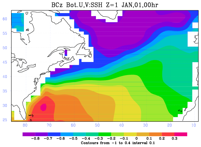
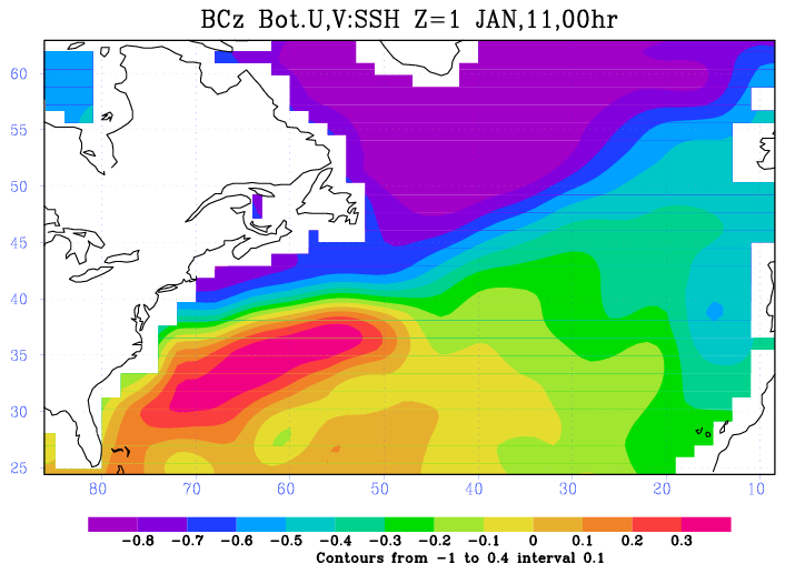
Considering a full-physics global ocean model, we apply the 4D-Var data assimilation technique to ORCA-2 configuration of the NEMO in order to identify the optimal parametrization of boundary conditions on the lateral boundaries as well as on the bottom and on the surface of the ocean [71] . The influence of boundary conditions on the solution is analyzed as in the assimilation window and beyond the window. It is shown that optimal surface and bottom boundary conditions allow us to better represent the jet streams, such as Gulf Stream and Kuroshio. Sea Surface Height in the North Atlantic before and after control is shown in fig.4 ). Analyzing the reasons of the jets reinforcement, we notice that data assimilation has a major impact on parametrization of the bottom boundary conditions for and [55] .
Adjoint models, necessary to variational data assimilation have been produced by the TAPENADE software, developed by the TROPICS team. This software is shown to be able to produce the adjoint code, that can be used in data assimilation after a memory usage optimization.
|
Direct assimilation of sequences of images
Participants : François-Xavier Le Dimet, Maëlle Nodet, Nicolas Papadakis, Arthur Vidard, Vincent Chabot.
At the present time the observation of Earth from space is done by more than thirty satellites. These platforms provide two kinds of observational information:
Eulerian information as radiance measurements: the radiative properties of the earth and its fluid envelops. These data can be plugged into numerical models by solving some inverse problems.
Lagrangian information: the movement of fronts and vortices give information on the dynamics of the fluid. Presently this information is scarcely used in meteorology by following small cumulus clouds and using them as Lagrangian tracers, but the selection of these clouds must be done by hand and the altitude of the selected clouds must be known. This is done by using the temperature of the top of the cloud.
MOISE was the leader of the ANR ADDISA project dedicated to the assimilation of images, and is a member of its current follow-up GeoFluids (along with EPI FLUMINANCE and CLIME, and LMD, IFREMER and Météo-France)
During the ADDISA project we developed Direct Image Sequences Assimilation (DISA) and proposed a new scheme for the regularization of optical flow problems [95] . Thanks to the nonlinear brightness assumption, we proposed an algorithm to estimate the motion between two images, based on the minimization of a nonlinear cost function. We proved its efficiency and robustness on simulated and experimental geophysical flows [78] . As part of the ANR project GeoFluids, we are investigating new ways to define distance between a couple of images. One idea is to compare the gradient of the images rather than the actual value of the pixels. This leads to promising results. Another idea, currently under investigation, consists in comparing mains structures within each image. This can be done using, for example, a wavelet representation of images. We are also part of TOMMI, another ANR project started mid 2011, where we are investigating the possibility to use optimal transportation based distances for images assimilation.
Assimilation of ocean images
Participants : Vincent Chabot, Maëlle Nodet, Nicolas Papadakis, Arthur Vidard, Alexandros Makris.
In addition with the direct assimilation approach previously described, a particular attention has been given to the study of data noise for ocean image assimilation. A journal paper is about to be submitted on this subject in Tellus A. In the context of assimilation of structures contained in satellite images, a two step registration approach using computer vision tools has been proposed within the post-doctorate of Alexandros Makris [33] , [56] .