Section: New Results
Assimilation of Images
Participants : Elise Arnaud, François-Xavier Le Dimet, Maëlle Nodet, Arthur Vidard, Nelson Feyeux.
Direct assimilation of image sequences
At the present time the observation of Earth from space is done by more than thirty satellites. These platforms provide two kinds of observational information:
-
Eulerian information as radiance measurements: the radiative properties of the earth and its fluid envelops. These data can be plugged into numerical models by solving some inverse problems.
-
Lagrangian information: the movement of fronts and vortices give information on the dynamics of the fluid. Presently this information is scarcely used in meteorology by following small cumulus clouds and using them as Lagrangian tracers, but the selection of these clouds must be done by hand and the altitude of the selected clouds must be known. This is done by using the temperature of the top of the cloud.
MOISE was the leader of the ANR ADDISA project dedicated to the assimilation of images, and is a member of its follow-up GeoFluids (along with EPI FLUMINANCE and CLIME, and LMD, IFREMER and Météo-France) that ended in 2013.
During the ADDISA project we developed Direct Image Sequences Assimilation (DISA) and proposed a new scheme for the regularization of optical flow problems [77], which was recently extended [76]. Thanks to the nonlinear brightness assumption, we proposed an algorithm to estimate the motion between two images, based on the minimization of a nonlinear cost function. We proved its efficiency and robustness on simulated and experimental geophysical flows. As part of the ANR project GeoFluids, we are investigating new ways to define distance between a couple of images. One idea is to compare the gradient of the images rather than the actual value of the pixels. This leads to promising results. Another idea, currently under investigation, consists in comparing main structures within each image. This can be done using, for example, a wavelet representation of images. Both approaches have been compared, in particular their relative merits in dealing with observation errors. This work has been extended to the progressive assimilation of different scales contained in the observations [22]
In recent developments we have also used "Level Sets" methods to describe the evolution of the images. The advantage of this approach is that it permits, thanks to the level sets function, to consider the images as a state variable of the problem. We have derived an Optimality System including the level sets of the images. This approach is being applied to the tracking of oceanic oil spills [41]
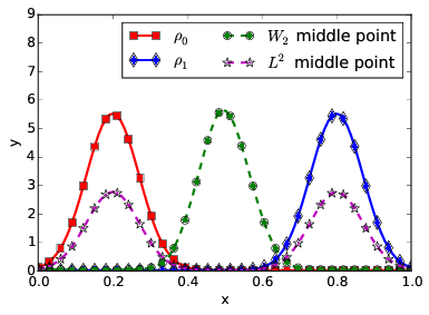
Optimal transport for image assimilation
We investigate the use of optimal transport based distances for data assimilation, and in particular for assimilating dense data such as images. The PhD thesis of N. Feyeux studied the impact of using the Wasserstein distance in place of the classical Euclidean distance (pixel to pixel comparison). In a simplified one dimensional framework, we showed that the Wasserstein distance is indeed promising. Figure 2 illustrates the advantage of using Wasserstein over : imagine that the density represents the observation, the background, and that we wish to find the "best" interpolation of the two. The "middle point" between them in the sense of the distance does not have the correct characteristics: its amplitude is smaller, and its shape is not correct as well. On the contrary, the middle point presents a similar structure and is indeed physically a better candidate for the interpolation of and . Data assimilation experiments with the Shallow Water model have been realised and confirm the interest of the Wasserstein distance. Results have been presented at ISDA conference [35] and a paper has been submitted [34]. N. Feyeux will defend his PhD thesis on Dec. 8th.