Section: New Results
Markov random fields and Marked point processes
Stochastic modeling for very high resolution SAR image processing
Participants : Aurélie Voisin, Vladimir Krylov, Josiane Zerubia [contact] .
This work was done in collaboration with DITEN, University of Genoa, with Dr. Gabriele Moser and Pr. Sebastiano B. Serpico with partial financial support of the French Defense Agency, DGA (http://www.defense.gouv.fr/dga/ ). The data were provided by the Italian Space Agency, ISA (http://www.asi.it/en ) in the framework of the project “Development and validation of multitemporal image analysis methodologies for multirisk monitoring of critical structures and infrastructures (2010-2012)”.
high resolution, synthetic aperture radar data, multi-sensor data, urban areas, supervised classification, hierarchical Markov random fields, statistical modeling, wavelets, textural features
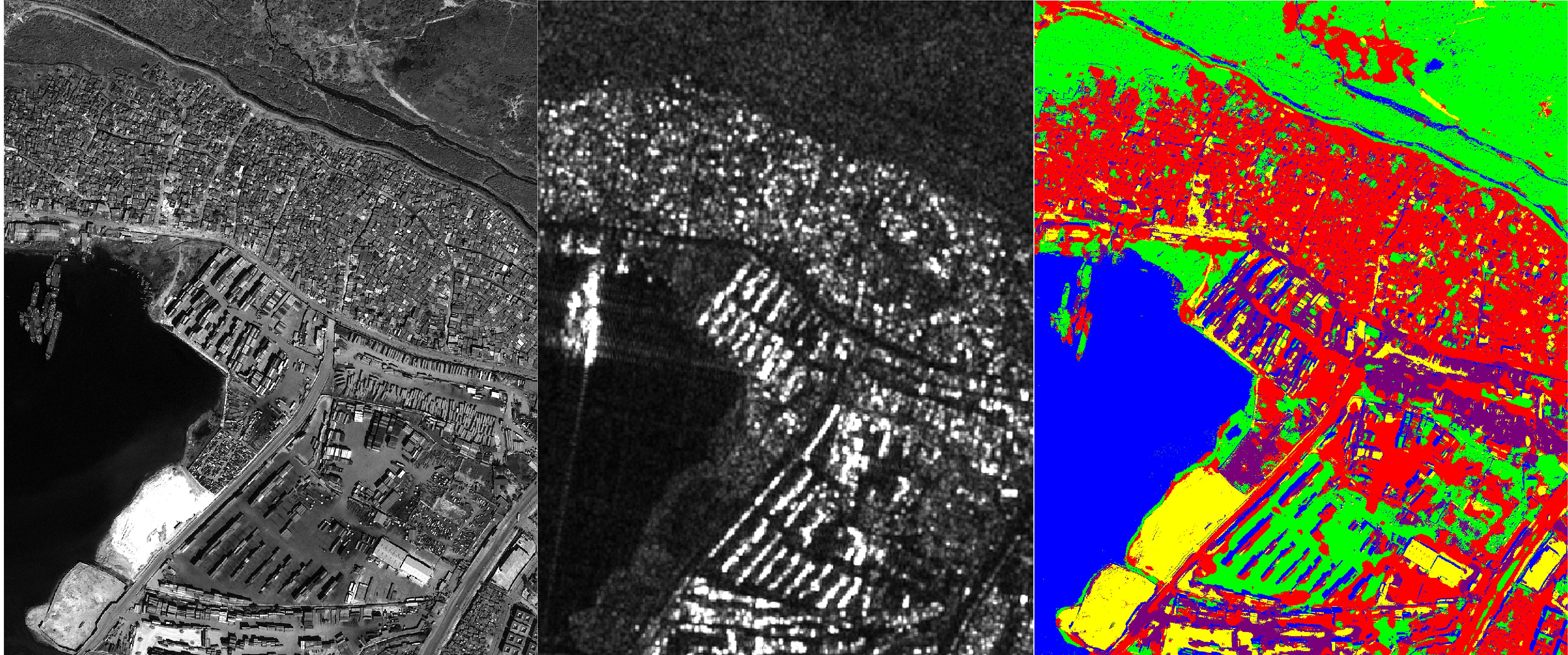
The classification of remote sensing images including urban areas is relevant in the context of the management of natural disasters (earthquakes, floodings...), and allows to determine land-use and establish land cover maps, or to localise damaged areas. Given the huge amount and variety of data available nowadays, the main difficulty is to find a classifier that takes into account multi-band, multi-resolution, and possibly multi-sensor data. A minor part of our work was also dedicated to the change detection [14] , still in the frame of the management of natural disasters.
We developed a supervised Bayesian classifier that combines a joint class-conditional statistical modeling and a hierarchical Markov random field. The first classification step deals with the statistical modeling for each target class (e.g. vegetation, urban, etc.) by using a finite mixture model, estimated by resorting to a modified stochastic expectation maximization (SEM) algorithm. Such a model is well-adapted to deal with heterogeneous classes, and each mixture component reflects the contribution of the different materials contained in a given class. When considering optical images, the statistics are modeled by using finite mixtures of Gaussian distributions. In the case of SAR amplitude imagery, we favor a finite mixture of generalized Gamma distributions. Then, at each considered resolution, the different input bands are statistically combined by using multivariate copulas. The second classification step relies on the integration of this statistical modeling in a hierarchical Markov random field integrated in a quad-tree structure. Such contextual classifier helps improving the robustness of the method with respect to noise, or to SAR speckle. A variety of algorithms were proposed to estimate the labels on hierarchical graphs. The consideration of a specific graph, here a quad-tree, allows to benefit from its good properties (e.g. causality) and to apply non iterative algorithms. Among the different algorithms employed in the literature, we chose to take into account an exact estimator of the marginal posterior mode (MPM). The cost function associated to this estimator offers the possibility to penalize the errors according to their number and the scale at which they occur: an error at the coarsest scale is stronger penalized than an error at the finest scale. Moreover, we introduce a prior estimation update that experimentally leads to improved results.
The first experiments were run on single-polarized, mono-resolution synthetic aperture radar (SAR) amplitude images. The challenge of the problem considered here is that the given input is at a single resolution and should be integrated in a multi-scale tree. Thus, we extract an extra information in the form of a multi-scale wavelet decomposition from the initial image. Then, at each level, a textural feature map (e.g. Haralick's variance) is obtained from each image in the decomposition stack, and integrated as an additional information that aims at discriminating the urban areas. Finally, at each level, the wavelet image is combined with the textural image by using copulas, as described previously. These results were presented in [10] , [23] .
Such a classifier is sufficiently flexible to take into account different types of data [21] , [22] . Thus, we also tested coregistered data of a given area acquired at different resolutions (e.g., multiresolution SAR images), directly integrated at the different levels of the hierarchical tree. The classification of multisensor (optical/SAR) data is illustrated in Fig. 1 . In this specific example, we consider a GeoEye acquisition (resolution: 65 centimeters) and a coregistered COSMO-SkyMed SAR acquisition (resolution: meters) of the Port-au-Prince quay (Haiti). Spatially disjoint training and test areas were manually annotated. The classification is done following 5 classes: urban areas, natural landscape, sand, containers and wet areas.
|
We have also run experiments on other types of acquisitions, such as histological images [22] , to prove the robustness of the proposed algorithm with respect to different image sources.
Satellite image classification using Bootstrap EM
Participants : Siddharth Buddhiraju, Josiane Zerubia [contact] .
This program has been partially funded by the Direction of International Relations of Inria (DRI).
Bootstrapping, Expectation-Maximization Algorithm, Iterated Conditional Expectation, Markov Random Fields, Simulated Annealing.
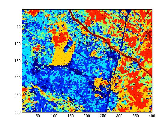
We implemented both Bootstrap EM and Iterated Conditional Expectation algorithms for parameter estimation of first order Markov Random Field models followed by Simulated Annealing, for optimal segmentation of gray-scale images. The objective was to perform a quantitative comparison of the two methods. Apart from successful implementation of these algorithms, an extension of these to multispectral images was performed, and the obtained results were found to be of superior quality compared against the original gray-scale ones (see Fig. 2 ).
First, Bootstrapped EM or Iterated Conditional Expectation were performed based on the user's requirement. The estimated parameters were then used to obtain the optimal segmentation of the image via simulated annealing. The algorithm was extended using multivariate Gaussian models to perform the same for multispectral images.
|
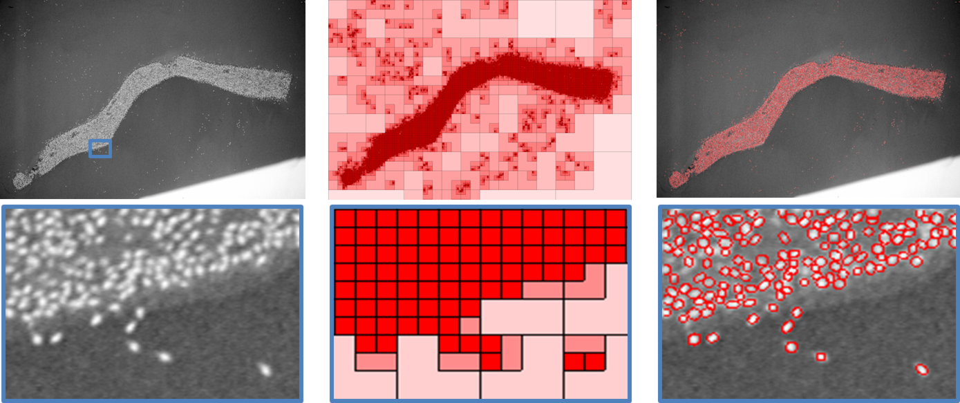
Boat detection and counting in Mediterranean Harbors using Marked Point Processes
Participants : Paula Craciun, Josiane Zerubia [contact] .
This work has been conducted in collaboration with ACRI-ST (http://www.acri-st.fr/ ) and the French Space Agency (http://www.cnes.fr/ ), which provided the high resolution satellite images.
stochastic modeling, marked point process, object extraction, SEM, simulated annealing
Marked point processes have been successfully applied in image processing analysis, when dealing with high resolution images in the purpose of feature extraction. The objective of this research was to improve the already existing marked point process model of ellipses to better fit the detection of boats in a harbor. The model involved two types of energy terms: a data term, used to determine the fidelity to the existing data (i.e. image) and a prior energy term, used to describe relationships between the objects. We proposed new energy components to model boat detection. The proposed model relied on a high number of parameters. While most of these parameters had an intuitive meaning and could be, thus, set manually, others were difficult to determine. We therefore used a parameter estimation method, based on the Stochastic Expectation - Maximization (SEM) algorithm, which proved to provide good results when combined with marked point processes. Furthermore, we proposed additional automatic procedures based on mathematical morphology to determine critical parameters of this model. Experimental results of boat detection are shown on Fig. 3 .
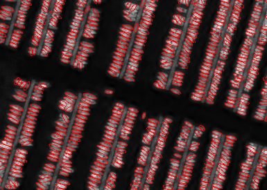
Contribution of object recognition on forest canopy images to the building of an allometric theory for trees and natural, heterogeneous forests
Participants : Jia Zhou, Josiane Zerubia [contact] .
This work was done in collaboration with Xavier Descombes (Morpheme team, Inria-SAM), Dr. Pierre Coureron and Dr. Christophe Proisy at IRD, UMR AMAP (http://amap.cirad.fr/ ), Montpellier.
object detection, marked point processes, tree crowns, forest structure
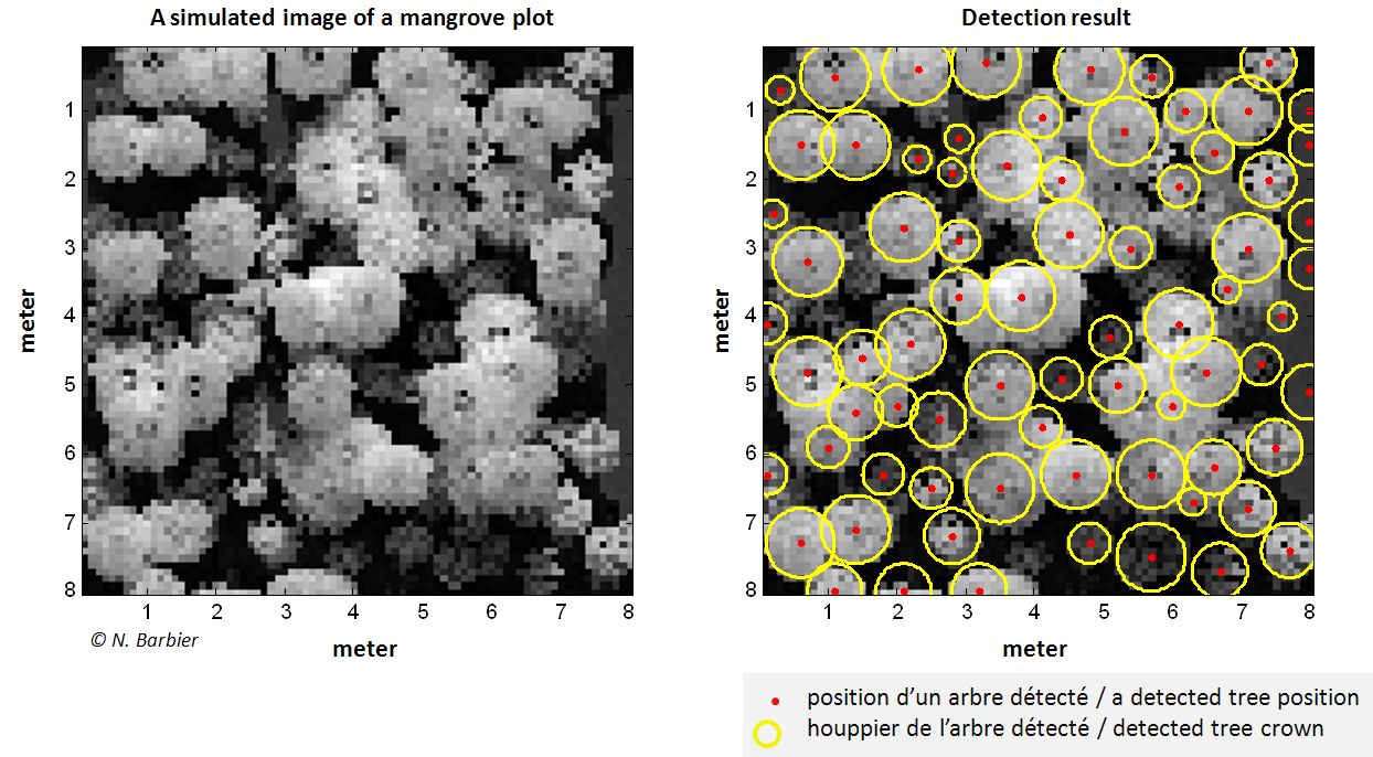
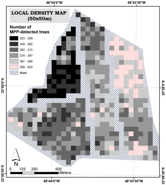
This work aimed at providing information on the forest structure through the analysis of canopy properties as described by the spatial distribution and the crown size of dominant trees. Our approach was based on the Marked Point Processes (MPP) theory, which allows modeling tree crowns observed in remote sensing images by discs belonging to a two dimensional space. The potential of MPP to detect the trees crowns automatically was evaluated by using very high spatial resolution optical satellite images of both Eucalyptus plantations in Brazil and mangrove forest in French Guyana. LIDAR and simulated reflectance images were also analyzed for the mangrove application. Different adaptations (parameter settings, energy models) of the MPP method were tested and compared through the development of quantitative indices that allowed comparison between detection results and tree references derived from the field, photo-interpretation or the forest mockups.
In the case of mangroves, the estimated crown sizes from detections were consistent with the outputs from the available allometric models (Fig. 4 (Left and Middle)). Other results indicated that tree detection by MPP allowed mapping the local density of trees of young Eucalyptus plantations (Fig. 4 (Right), [11] ) even if crown size was close to the image spatial resolution (0.5 m). However, the quality of detection by MPP decreased with canopy closeness. To improve the results, further work may involve MPP detection using objects with finer shapes and forest data measurements collected at the tree plant scale.
|
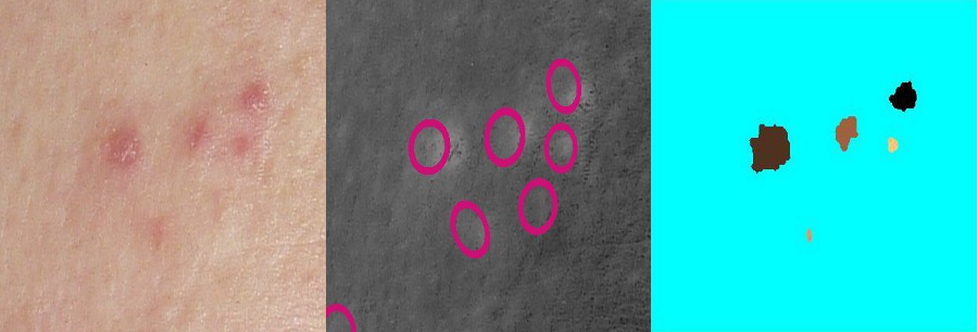
Detection of the hyperpigmentation of the skin on color images using Marked Point Process and Mathematical Morphology
Participants : Adrien Lacage, Josiane Zerubia [contact] .
The source images were provided by the AYIN team itself for the study of folliculitis, and by an industrial leader in skin care for acne.
skin care, hyperpigmentation, acne, folliculitis, marked point process, mathematical morphology
Automatic detection of the skin hyperpigmentation helps in estimating the severity of some skin diseases like acne vulgaris and folliculitis. We compared two methods for studying acne and folliculitis lesions and hyperpigmentation of the skin. We adapted a model based on Marked Point Processes and initially developed for flamingo's population counting to dermatological images of acne and folliculitis. Then, we developed an algorithm which uses mathematical morphology together with volume and shadows compensation. Finally, we compared results in term of detection accuracy.
|
Efficient Monte Carlo sampler for detecting parametric objects in large scenes
Participants : Yannick Verdie, Florent Lafarge [contact] .
This work is supervised by Florent Lafarge (Geometrica team, Inria-SAM) in collaboration with the AYIN team.
Point processes have demonstrated both efficiency and relevance when addressing object recognition problems in vision. However, simulating these mathematical models is a difficult task, especially on large scenes. Existing samplers suffer from average performances in terms of computation time and stability. We propose a new sampling procedure based on a Monte Carlo formalism. Our algorithm exploits Markovian properties of point processes to perform the sampling in parallel. This procedure is embedded into a data-driven mechanism such that the points are non-uniformly distributed in the scene. The performances of the sampler are analyzed through a set of experiments on various object recognition problems from large scenes, and through comparisons to the existing algorithms.
|