Section: New Results
3D object and scene modeling, analysis, and retrieval
People Watching: Human Actions as a Cue for Single View Geometry
Participants : Vincent Delaitre, Ivan Laptev, Josef Sivic, Alexei Efros [CMU] , David Fouhey [CMU] , Abhinav Gupta [CMU] .
We present an approach which exploits the coupling between human actions and scene geometry. We investigate the use of human pose as a cue for single-view 3D scene understanding. Our method builds upon recent advances in still-image pose estimation to extract functional and geometric constraints about the scene. These constraints are then used to improve state-of-the-art single-view 3D scene understanding approaches. The proposed method is validated on a collection of monocular time lapse sequences collected from YouTube and a dataset of still images of indoor scenes. We demonstrate that observing people performing different actions can significantly improve estimates of 3D scene geometry.
This work has been published in [11] .
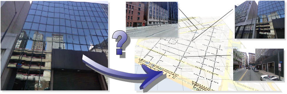
Learning and Calibrating Per-Location Classifiers for Visual Place Recognition
Participants : Petr Gronát, Josef Sivic, Guillaume Obozinski [Inria SIERRA] , Tomáš Pajdla [CTU in Prague] .
The aim of this work is to localize a query photograph by finding other images depicting the same place in a large geotagged image database. This is a challenging task due to changes in viewpoint, imaging conditions and the large size of the image database. The contribution of this work is two-fold. First, we cast the place recognition problem as a classification task and use the available geotags to train a classifier for each location in the database in a similar manner to per-exemplar SVMs in object recognition. Second, as only few positive training examples are available for each location, we propose a new approach to calibrate all the per-location SVM classifiers using only the negative examples. The calibration we propose relies on a significance measure essentially equivalent to the p-values classically used in statistical hypothesis testing. Experiments are performed on a database of 25,000 geotagged street view images of Pittsburgh and demonstrate improved place recognition accuracy of the proposed approach over the previous work. The problem addressed in this work is illustrated in Figure 1 .
This work has been submitted to CVPR 2013.
|
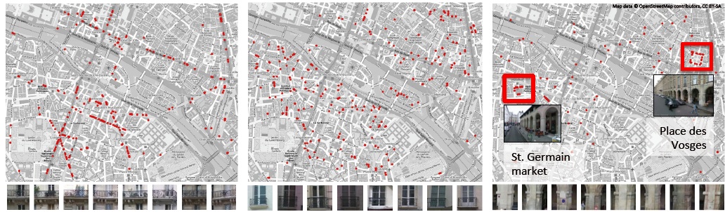
What Makes Paris Look like Paris?
Participants : Josef Sivic, Carl Doersch [CMU] , Saurabh Singh [UIUC] , Abhinav Gupta [CMU] , Alexei Efros [CMU] .
Given a large repository of geotagged imagery, we seek to automatically find visual elements, e.g. windows, balconies, and street signs, that are most distinctive for a certain geo-spatial area, for example the city of Paris. This is a tremendously difficult task as the visual features distinguishing architectural elements of different places can be very subtle. In addition, we face a hard search problem: given all possible patches in all images, which of them are both frequently occurring and geographically informative? To address these issues, we propose to use a discriminative clustering approach able to take into account the weak geographic supervision. We show that geographically representative image elements can be discovered automatically from Google Street View imagery in a discriminative manner. We demonstrate that these elements are visually interpretable and perceptually geo-informative. The discovered visual elements can also support a variety of computational geography tasks, such as mapping architectural correspondences and influences within and across cities, finding representative elements at different geo-spatial scales, and geographically-informed image retrieval. Example result is shown in Figure 2 .
This work has been published in [6] .
|