

Section: New Results
An Evaluation of Interactive Map Comparison Techniques
|
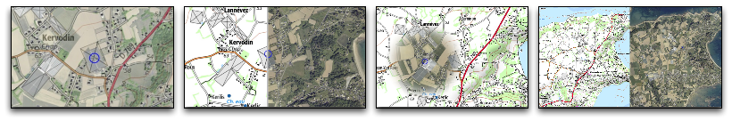
Geovisualization applications typically organize data into layers. These layers hold different types of geographical features, describe different characteristics of the same features, or represent those features at different points in time. Layers can be composited in various ways, most often employing a juxtaposition or superimposition strategy, to produce maps that users can explore interactively. From an HCI perspective, one of the main challenges is to design interactive compositions that optimize the legibility of the resulting map and that ease layer comparison. We characterized five representative techniques, and empirically evaluated them using a set of real-world maps in which we purposefully introduced six types of differences amenable to inter-layer visual comparison. We discussed the merits of these techniques in terms of visual interference, user attention and scanning strategy. Those results can help inform the design of map-based visualizations for supporting geo-analysis tasks in many application areas.
This work was published at ACM CHI 2015 [4] , and received an honorable mention (top 5% of all submissions).