

Section: New Results
Reconstruction
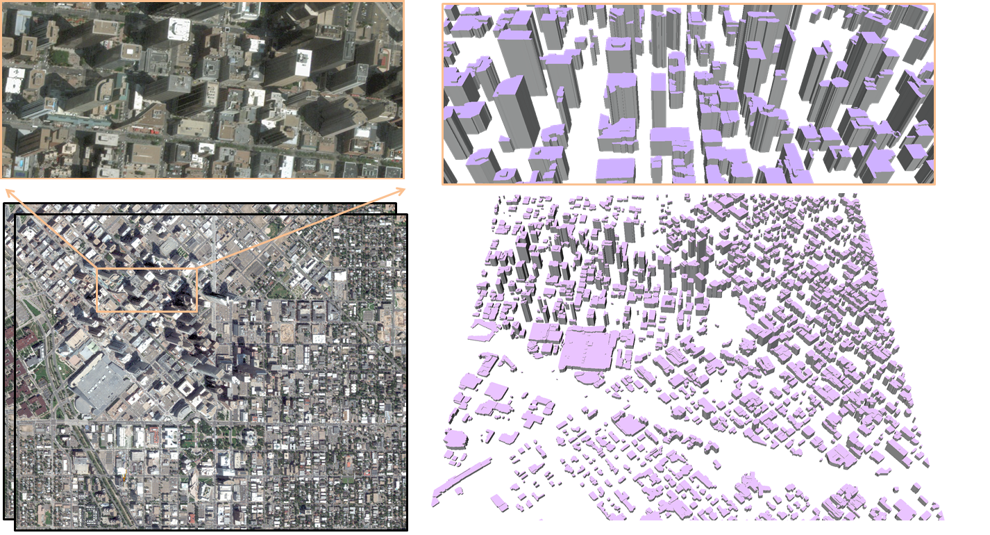
Towards Large-scale City Reconstruction from Satellites
Participants : Liuyun Duan, Florent Lafarge.
In collaboration with Geoimage.
Automatic city modeling from satellite imagery is one of the biggest challenges in urban reconstruction. Existing methods produce at best rough and dense Digital Surface Models. Inspired by recent works on semantic 3D reconstruction and region-based stereovision, we propose a method for producing compact, semantic-aware and geometrically accurate 3D city models from stereo pair of satellite images [8]. Our approach relies on two key ingredients. First, geometry and semantics are retrieved simultaneously bringing robustness to occlusions and to low image quality. Second, we operate at the scale of geometric atomic region which allows the shape of urban objects to be well preserved, and a gain in scalability and efficiency. We demonstrate the potential of our algorithm by reconstructing different cities around the world in a few minutes (See Figure 7). This work has been published in the proceedings of the European Conference on Computer Vision (ECCV).
|
A Survey of Surface Reconstruction from Point Clouds
Participant : Pierre Alliez.
In collaboration with Matthew Berger, Andrea Tagliasacchi, Lee Seversky, Gael Guennebaud (Inria MANAO), Joshua Levine, Andrei Sharf and Claudio Silva.
The area of surface reconstruction has seen substantial progress in the past two decades. The traditional problem addressed by surface reconstruction is to recover the digital representation of a physical shape that has been scanned, where the scanned data contains a wide variety of defects. While much of the earlier work has been focused on reconstructing a piece-wise smooth representation of the original shape, recent work has taken on more specialized priors to address significantly challenging data imperfections, where the reconstruction can take on different representations – not necessarily the explicit geometry. We survey the field of surface reconstruction, and provide a categorization with respect to priors, data imperfections, and reconstruction output. By considering a holistic view of surface reconstruction, we show a detailed characterization of the field, highlight similarities between diverse reconstruction techniques, and provide directions for future work in surface reconstruction. This survey was published in Computer Graphics Forum [2].